Wittmoor bog trackway
The trackways date to the 4th and 7th century AD, both linked the eastern and western shores of the formerly inaccessible, swampy bog.
In 1898 Ludwig Frahm, a local school teacher and historian followed a hint from Hinrich Mohr, a carpenter from Poppenbüttel, showing him the location of what he called a Russian causeway which is actually trackway No.
Even during World War II most of the western part of the pead bog were cut for fuel production which destroyed large sections of the trackway.
In 1947 approximately 2 metres (6.6 ft) of the central part was excavated by Kellermann in 1947 which is now on displayed in the permanent collection of the Archaeological Museum in Hamburg.
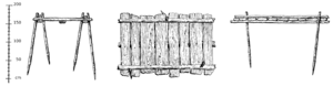
The substructure of the road consisted of two split oak planks that were placed parallel to each other on a sand or gravel foundation on the formerly swampy terrain.
Beside it newly trimmed timbers were found which were designed to be built in the new way, as well as items interpreted as tools, like a crowbar and mallet.
[5] They show that in earlier times, a lively exchange between the western and eastern shores of the marshland occurred, and that the routes were considered so important that a significant logistical and substantive effort was expended to build paths through the marsh rather than circumvent the area.