The Witwatersrand (UK: /wɪtˈwɔːtərzrænd, -rɑːnd/, US also /ˈwɪtwɔːtərz-/;[1] Afrikaans pronunciation: [ˌvətˌvɑːtərsˈrant]; locally the Rand or, less commonly, the Reef) is a 56-kilometre-long (35 mi), north-facing scarp in South Africa.
It consists of a hard, erosion-resistant quartzite metamorphic rock, over which several north-flowing rivers form waterfalls, which account for the name Witwatersrand, meaning 'white water ridge' in Afrikaans.
[3][7][8] Because of the extraordinary quantities of gold that have been extracted from the Witwatersrand rocks, the South African currency was named the rand in 1961 upon the declaration of the republic.
[9] The entire series of rocks, known as the "Witwatersrand Supergroup", consists of very hard erosion resistant quartzites, banded ironstones and some marine lava deposits, interspersed with softer, more easily eroded tillites, mudstones and conglomerates.
[9] The entire series of rocks, known as the "Witwatersrand Supergroup" consists of quartzites, banded ironstones, mudstones, tillites, conglomerates and some marine lava deposits.
Most of the basin is deeply buried under younger rocks, but outcrops occur in Gauteng, the Free State, as well as in some of the surrounding Provinces.
[3][2] However, when it was found that, traced downdip, the conglomerate was not merely developed for the narrow width of a river, but continued in depth, there came the realisation that this conglomeratic zone was part of a sedimentary succession.
[2] The conglomerate was quickly traced east and westward for a total continuous distance of 50 km (31 mi) to define what became known as the "Central Rand Gold Field".
It has since been established that the rocks that make up the Witwatersrand Ridge dip downwards and southwards to form the largely underground "Witwatersrand Basin" which covers an elliptical area with a 300 km (190 mi) long major axis from Evander in the north-east to Theunissen in the south-west, and 150 km (93 mi) wide stretching from Steynsrus in the south-east to Coligny in the north-west,[2] with a small subsidiary basin at Kinross.
[3][2] Although many of the older mines, around Johannesburg, are now nearly exhausted, the Witwatersrand Basin still produces most of South Africa's gold and much of the total world output.
It was the coalescence of several of these island arcs that led to the formation of the Kaapvaal Craton, one of the first microcontinents to form on Earth about 3.9 billion years ago.
About 3 billion years ago local cooling of the underlying asthenosphere caused subsidence of the south eastern portion of this microcontinent below sea level.
[13] The oxygen produced by these microorganisms rapidly reacted with, amongst others, Fe2+ ions dissolved in water, precipitating insoluble red iron oxide (hematite).
Changing geographical conditions resulted in the accumulation of a wide variety of sediments, ranging from mud, to sand, to gravel, and banded ironstones.
[9][15] Within 60 million years, up to 4500 m of sediment had accumulated on the granite base, to become the "West Rand Group" of rocks that contribute over 60% of the total thickness of the Witwatersrand Supergroup.
[3][9][15] Uplifting of the north of the Kaapvaal Craton, in addition to orogenesis (mountain formation), towards the end of the deposition of the "West Rand Group" of sediments caused the Witwatersrand sea to retreat.
It is the younger Central Rand Group that contains most of the gold bearing conglomerates, locally referred to as banket, that are today of great economic importance.
[16] The gold in the Witwatersrand Basin area was deposited in Archean river deltas having been washed down from surrounding gold-rich greenstone belts to the north and west.
Rhenium-osmium isotope studies indicate that the gold in those mineral deposits came from unusual 3 billion year old mantle-derived intrusions known as komatiite, present in the greenstone belts.
Iron pyrite (FeS2), which is relatively plentiful in the gold ores of the Witwatersrand, oxidises to insoluble ferric oxide (Fe2O3) and sulfuric acid (H2SO4).
[2][3] However, when it was found that, traced downdip, the conglomerate was not merely developed for the narrow width of a river, but continued in depth, there came the realisation that this conglomeratic zone was part of a sedimentary succession.
The conglomerate was quickly traced east and westward for a total continuous distance of 50 km (31 mi) to define what became known as the "Central Rand Gold Field".
A diagrammatic north–south cross section through the Witwatersrand ridge / plateau, below the Johannesburg city center. Only the major subgroups of rocks are shown, each of which is made up of many separate layers of varying composition. The harder layers form the hills, and the softer layers the valleys. The oldest rocks of the Witwatersrand Supergroup form the Orange Grove Quartzite layer. This forms the scarp in the north, from which the Witwatersrand derives its name. The granite to the north of the Orange Grove Quartzite scarp is around 3.2 billion years old, and is an exposed portion of the underlying
Kaapvaal Craton
on which a large portion of South Africa rests. (See illustration below.) To place this diagram into its broader context, see the diagrammatic geological cross section through the
Vredefort impact structure
at the end of the article.
Witwatersrand Basin and major goldfields
Carbon Leader Gold Ore, Blyvooruitzicht Gold Mine, Carletonville Goldfield, West Witwatersrand. The Carbon Leader is a blackened, hydrocarbon-rich stromatolitic interval richly impregnated with
native gold
and
uraninite
. This is a paleoplacer deposit, part of an ancient alluvial fan succession.
High-grade gold ore from the Witwatersrand near
Johannesburg
.
A timeline of the Earth's geological history, with an emphasis on events in Southern Africa.
W
indicates when the Witwatersrand supergroup was laid down,
C
the
Cape supergroup
, and
K
the
Karoo Supergroup
. The graph also indicates the period during which
banded ironstone formations
were formed on Earth, indicative of an
oxygen-free atmosphere
. The Earth's crust was wholly or partially molten during the
Hadean
Eon; the oldest rocks on Earth are therefore less than 4000 million years old. One of the first microcontinents to form was the
Kaapvaal Craton
.
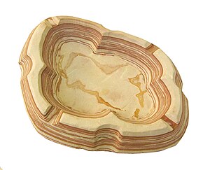
An ashtray carved out of a soft form of
banded ironstone
. Note the alternating red and beige layers that make up this rock. The red layers are much richer in iron (III) oxides (
Fe
2
O
3
) and were laid down during time periods when
Archean
photosynthesizing
cyanobacteria
produced
oxygen
that rapidly reacted with the dissolved iron (II) (
Fe
2+
) in water, to form insoluble
iron oxide
(
hematite
). The beige layers are sediments that settled during time periods when there was no (or much less) precipitation of iron oxide due to the depletion of dissolved oxygen or
Fe
2+
in water. The
earth's atmosphere was oxygen-free
until about 2 billion years ago, when the rate of photosynthetic oxygen production began to exceed its rate of reaction with oxidizable substances (i.e. reducing agents such as
Fe
2+
, or
HS
−
).
[
13
]
A diagrammatic representation of the position and size of the
Kaapvaal Craton
, outlined in red, in relation to present-day
Southern Africa
. The blue area depicts the portion of the
craton
that subsided below the "Witwatersrand Sea", about 3 billion years ago. It is in this sea that the sediments accumulated and would ultimately form the "West Rand Group" portion of the "Witwatersrand Supergroup" of rocks. The younger "Central Rand Group" of rocks accumulated on the low, flat coastal plain (see diagram below) after the Witwatersrand Sea had retreated southwards as a result of uplifting of the craton, especially in the north.
CT
indicates Cape Town,
D
Durban,
B
Bloemfontein,
J
Johannesburg, and
K
Kimberley.
A diagrammatic presentation of the rivers that flowed into the Witwatersrand sea after 43000 m of sediment had already been deposited in the basin. The fast flowing rivers cascading down the mountains to the north now flowed over a wide flat coastal plain to form broad deltas of sluggish braided rivers, where the heavy materials (cobbles, gold, uranium and iron pyrite etc.) carried down from the mountains settled out, to form the gold bearing "Central Rand Group" deposits. Today's gold ore is confined to the fossil river deltas.
The position of the Kaapvaal Craton (khaki coloured area) beneath the South African landscape, and the shrunken, shallow Witwatersrand Sea (light blue) at the time that gold was deposited in the broad, river deltas of six rivers that flowed into that sea, dropping all their heavier materials (cobbles, gold, uranium iron pyrite etc.) in the braided rivers of the deltas (see illustration on the left). Most of these gold deposits are deep under the South African surface, but form outcrops (exposures at the surface) along the Witwatersrand ridge. The six gold fields thus established are, in order from the west, moving clockwise, to the northern shore of the Witwatersrand sea,
Welkom
,
Klerksdorp
,
Carletonville
,
West Rand
,
East Rand
and
Evander
.
[
2
]
A schematic diagram of a NE (left) to SW (right) cross-section through the 2020 million year old
Vredefort impact structure
and how it distorted the contemporary geological structures. The present erosion level is shown.
Johannesburg
is located where the Witwatersrand Basin (yellow layer) is exposed at the "present surface" line, just inside the crater rim, on the left. Not to scale.
A schematic diagram of the area surrounding the
Vredefort Dome
, where a massive meteor created an impact crater 300 km in diameter 2,02 billion years ago. The red dot represents the point of impact. The outer circle has a radius of 150 km, and indicates the approximate location of the crater rim. The inner circle marks the 100 km distance from the centre. Note that the outcrops (surface exposures) of Witwatersrand rocks (yellow areas) are located at 25 km from the point of impact and then again at about 80–120 km from the centre. The locations of important towns and cities in the region are indicate in the appropriate places. The red line in the detail of the Johannesburg region shows the location of the scarp/ridge that gave the "Witwatersrand" its name; the purple line the location where the main gold bearing reef is exposed at the surface, just south of Johannesburg.