Yamuna
It merges with the Ganges at Triveni Sangam, Prayagraj, which is a site of the Kumbh Mela, a Hindu festival held every 12 years.
It helps create the highly fertile alluvial Ganges-Yamuna Doab region between itself and the Ganges in the Indo-Gangetic plain.
An important part of its early catchment area, totalling 2,320 square kilometres (900 sq mi), lies in Himachal Pradesh.
The Tons, Yamuna's largest tributary, drains a large portion of the upper catchment area and holds more water than the main stream.
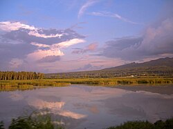
[11] From the upper catchment area, the river descends onto the plains of Doon Valley, at Dak Pathar near Dehradun.
When the Yamuna reaches the Indo-Gangetic plain, it runs almost parallel to the Ganges, the two rivers creating the Ganges-Yamuna Doab region.
Spread across 69,000 square kilometres (27,000 sq mi), one-third of the alluvial plain, the region is known for its agricultural output, particularly for the cultivation of basmati rice.
[12] Subsequently, the Yamuna flows through the states of Delhi, Haryana and Uttar Pradesh before merging with the Ganges at a sacred spot known as Triveni Sangam in Prayagraj.
During the Kumbh Mela, held every 12 years, large congregations of people immerse themselves in the sacred waters of the confluence.
[13] The cities of Baghpat, Delhi, Noida, Mathura, Agra, Firozabad, Etawah, Kalpi, Hamirpur, and Prayagraj lie on its banks.
[17] In the Rigveda, the story of the Yamuna describes her "excessive love" for her twin, Yama, who in turn asks her to find a suitable match for herself, which she does in Krishna.
[18] Yamuna is mentioned as Iomanes (Ioames) in the surveys of Seleucus I Nicator, an officer of Alexander the Great and one of the Diadochi, who visited India in 305 BCE.
Greek traveller and geographer Megasthenes visited India sometime before 288 BCE (the date of Chandragupta's death) and mentioned the river in his Indica, where he described the region around it as the land of Surasena.
While some have argued that this was due to a tectonic event, and may have led to the Sarasvati River drying up, the end of many Harappan civilisation settlements, and creation of the Thar desert,[20][21][22] recent geological research suggests that the diversion of the Yamuna to the Ganges may have occurred during the Pleistocene, and thus could not be connected to the decline of the Harappan civilisation in the region.
These rivers were revered throughout these kingdoms that flourished on their banks; since the period of Chandragupta II (r. 375–415 CE), statues both the Ganges and Yamuna became common throughout the Gupta Empire.
Further to the South, images of the Ganges and Yamuna are found amidst shrines of the Chalukyas, Rashtrakutas (753–982), and on their royal seals; prior to them, the Chola Empire also added the river into their architectural motifs.
The Three River Goddess shrine, next to the Kailash rock-cut Temple at Ellora, shows the Ganges flanked by the Yamuna and Saraswati.
The river take 60 hours to travel from Tajewala to Delhi, thus allowing a two-day advance flood warning period.
[3][26][27] The Central Water Commission started flood-forecasting services in 1958 with its first forecasting station on Yamuna at Delhi Railway Bridge.
Excessive silting caused it to stop flowing c. 1750, when the British Raj undertook a three-year renovation in 1817 by Bengal Engineer Group.
The canals irrigate vast tracts of land in the region in Ambala, Karnal, Sonipat, Rohtak, Jind, Hisar and Bhiwani districts.
[45] According to Hindu mythology, the River was brought to Earth by the ascetic practice of the Seven Sages where she first descended on Mount Kalinda.
[47] Some religious figures (notably pilgrim priests of Mathura and Vrindavan) do not regard the physical pollution of the Yamuna to have any effect on the river's spiritual purity.
[46] The Yamunashtakam is a 16th-century Sanskrit hymn composed by Vallabhacharya which describes the story of Yamuna's descent to meet her beloved Krishna and to purify the world.
A 2016 study shows that there is 100% urban metabolism of River Yamuna as it passes through the National Capital Territory (NCT) of Delhi.
Although it appeared similar to that resulting from cosmetic products such as soap or shampoo, experts determined that the foam was caused by heavy pollution, and was therefore hazardous.
A study has recommended that 23 cubic metres (23,000 L; 5,100 imp gal) per second of water should be released from Hathni Kund Barrage during the lean season to provide a minimum environmental flow in the Yamuna.
[citation needed] To address river pollution, measures have been taken by the Ministry of Environment and Forests (MoEF) in 12 towns of Haryana, 8 towns of Uttar Pradesh, and Delhi, under the Yamuna Action Plan (YAP) which has been implemented since 1993 by the MoEF's National River Conservation Directorate (NRCD).
[67][68][69][needs update] Under the YAP- III scheme, a new sewage treatment plant is being built at the largest such facility in India by the Delhi Jal Board (DJB).
[71] On 25 April 2014, the National Green Tribunal Act (NGA) recommended the government to declare a 52-kilometre (32 mi) stretch of the Yamuna in Delhi and Uttar Pradesh as a conservation zone.