Yustaga
[1] The Yustaga were closely associated with the Northern Utina people living on the other side of the Suwannee River, though they appear to have spoken a different dialect of the Timucua language, perhaps Potano.
Like all Timucua groups, they experienced significant demographic decline in the period of European contact, especially following raids by English-allied Indians from the north.
Surviving Yustaga eventually moved closer to the Spanish capital of St. Augustine and mingled with other missionized Indians, losing their independent identity.
From about 900 a derivative culture emerged among the peoples of the Suwannee River Valley, the groups later designated as the Yustaga and Northern Utina.
[7] Archaeological evidence suggests that the Yustaga, like the Northern Utina, lived in distinct groups of villages, probably representing small-scale local chiefdoms.
[1] Anthropologist John Worth suggests these might have been organized into a loose regional chiefdom that was continuous from at least the early period of European contact.
Possible evidence for this lies in the fact that later Spanish lists of Yustaga chiefs consistently name them in order of the prominence of their towns, with Potohiriba invariably first.
Additionally, the Spanish built a mission at Potohiriba before any other Yustaga town, despite its comparatively remote location, suggesting it was already a center of considerable regional importance.
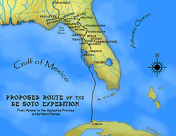
[11][12] However, the name "Yustaga" first appears in the chronicles of Hernando de Soto's 1539 expedition, which describe it as the region immediately east of Apalachee.
De Soto ultimately prevailed and subsequently executed Aguacaleycuen and other hostages, but by the time he got into Yustaga, the villages had already been evacuated.
[18] Spanish records indicate that the paramount chief of the Yustaga consistently refused to allow missionaries to even enter his territory until the 1620s, over twenty years after missionization had begun among the Northern Utina and other interior groups.
[19] Around 1623 the chief of Cotocochuni, probably the main village of the Yustaga regional chiefdom, finally consented to two friars entering his territory, though he forbade his subjects from getting baptized or providing the missionaries with food.
[19] Having much less frequent contact with the Europeans and the diseases they introduced, the Yustaga maintained stable population levels later than any other Timucua group.