St. Johns River
This basin, spreading throughout Orange, Lake, Volusia, and Seminole Counties, is home to the greater Orlando metropolitan area, where two million people live and major tourist attractions are located.
[18] Optimally an 8-foot (2.4 m) deep channel about 100 yards (91 m) wide after leaving Lake Monroe, the St. Johns meets its most significant tributary in the middle basin, the spring-fed Wekiva River, discharging approximately 42,000,000 US gallons (160,000,000 L) per day into the St.
[29] The U.S. Navy has two bases in the Jacksonville area: Naval Station Mayport, at the mouth of the river, serves as the second largest Atlantic Fleet operation and home port in the country.
[30] The largest kingfishing tournament in the U.S. is held on a St. Johns tributary, where sport fishers concentrate on king mackerel (Scomberomorus cavalla), cobia (Rachycentron canadum), dolphin (Coryphaena hippurus) and Wahoo (Acanthocybium solandri).
Sweetbay (Magnolia virginiana), cypress (Taxodium), and swamp tupelo (Nyssa biflora) trees often find great success in this region on raised land called hammocks.
[36] Flatwoods forests dominate the Lake George watershed, with slash pines (Pinus elliottii), saw palmetto (Serenoa repens), and over 100 species of groundcover or herbal plants that grow in poor, sandy soil.
[37] Typical mammals that live in these ecosystems, such as raccoons (Procyon lotor), opossums (Didelphis virginiana), bobcats (Lynx rufus), and white tailed-deer (Odocoileus virginianus), are ones that prefer dry, flat areas with good ground cover and available nesting sites.
Amphibious invertebrates such as apple snails (Pomacea paludosa), crayfish, and grass shrimp consume plant material, hastening its decomposition and acting as a food source for fish and birds.
The monkeys' introduction to Florida is unclear; they were reportedly brought either to serve in backdrop scenes of Tarzan movies filmed around the Silver River in the 1930s, or to lend an air of authenticity to "jungle cruises" provided by an enterprising boat operator around the same time.
[48] The proliferation of largemouth bass (Micropterus salmoides), black crappie (Pomoxis nigromaculatus), and bluegill (Lepomis macrochirus) in central Florida is a major attraction for fishermen from all over the country.
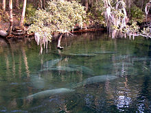
[49] Some are marine species that either migrate upriver to spawn or have found spring-fed habitats that are high in salinity, such as a colony of Atlantic stingrays (Dasyatis sabina) that live in Lake Washington in the upper basin.
The animals and plants in these systems can tolerate both fresh and salt water, and the fluctuations in saline content and temperatures associated with tidal surges and heavy rainfall discharge.
Fish such as mullet (Mullidae), flounder (Paralichthys lethostigma), shad (Alosa sapidissima), and blue crabs (Callinectes sapidus) migrate from the ocean to freshwater springs upriver to spawn.
Although freshwater invertebrates inhabiting and comprising algae and periphyton make the foundation of food webs in the middle and lower basin, zooplankton and phytoplankton take that role in the estuarine habitat.
Lying underneath the visible rock formations is a basement of igneous granite and volcanic composition under a sedimentary layer formed during the Paleozoic era 542 to 251 million years ago.
During the Cretaceous period (145 to 66 million years ago), the basement and its sedimentary overlay were further covered by calcium carbonate and formations left by the evaporation of water called evaporites.
Geologists hypothesize that the west-flowing offset may have formed earlier than the north flowing portions, possibly during the late Tertiary or early Pleistocene era 66 to 12 million years ago.
Rapid decomposition of organic materials will decrease the amount of dissolved oxygen in the river, as will nutrients added to the water artificially by wastewater treatment runoff or drainage from fertilized agricultural fields.
[79] Around 9,000 years ago, the climate warmed, melting much of the polar ice caps and many glaciers, creating a wetter environment and submerging half the peninsular shelf.
[101] After Florida came under the Kingdom of Great Britain's jurisdiction in 1763, Quaker father and son naturalists John and William Bartram explored the length of the river while visiting the southeastern United States from 1765 to 1766.
They were charged by King George III to find the source of the river they called the Picolata or San Juan, and measured its widths and depths, taking soil samples as they traveled southward.
Subsequent explorers, including John James Audubon, have carried William's Travels Through North & South Carolina, Georgia, East & West Florida with them as a guide.
Even before Florida was under U.S. jurisdiction, Major General Andrew Jackson was responsible for removing the Alachua Seminoles west of the Suwannee River, either killing them or forcing them farther south towards Lake County, in 1818.
The result of Jackson's offensive was the transfer of Florida to the U.S.[111][note 3] Following the Seminole Wars, a gradual increase in commerce and population occurred on the St. Johns, made possible by steamship travel.
One action in Florida's role in the Civil War was the sinking of the USS Columbine, a Union paddle steamer used for patrolling the St. Johns to keep materials from reaching the Confederate Army.
[114][115] The same year and farther downriver, Confederates again sank a Union boat, the Maple Leaf, which struck a floating keg filled with explosives and settled into the muck near Julington Creek, south of Jacksonville.
Florida Governor William Bloxham in 1881 appealed directly to a Pennsylvania-based industrialist named Hamilton Disston, initially to build canals to improve steamboat passage through the Caloosahatchee River, and later to drain lands in the central part of the state for agriculture.
A spate of poor luck and tense British-American relations followed, prompting Fell to spend some years investing in infrastructure in Siberia, but he returned in 1909 with ideas of developing wetlands in central Florida.
[148] More than 19,000 acres (77 km2) have been purchased along Lake Apopka to restore its wetlands, and the SJRWMD has removed nearly 15,000,000 pounds (6,800,000 kg) of gizzard shad (Dorosoma cepedianum), a fish species that stores phosphorus and adds to algae problems.
[158] The National Research Council found that, overall, the District performed a competent job in relating predicted environmental responses, including their magnitude and general degree of uncertainty, to the proposed range of water withdrawals.