Zagros Mountains
It spans the southern parts of the Armenian highlands, and the whole length of the western and southwestern Iranian plateau, ending at the Strait of Hormuz.
Recent GPS measurements in Iran[6] have shown that this collision is still active and the resulting deformation is distributed non-uniformly in the country, mainly taken up in the major mountain belts like Alborz and Zagros.
The Zagros mountains were created around the time of the second ice age,[8] which caused the tectonic collision, leading to its uniqueness.
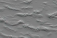
[10] Stresses induced in the Earth's crust by the collision caused extensive folding of the preexisting layered sedimentary rocks.
The depositional environment and tectonic history of the rocks were conducive to the formation and trapping of petroleum, and the Zagros region is an important area for oil production.
[16] Some settlements later grew into cities, eventually named Anshan and Susa; Jarmo is one archaeological site in this area.
[20] Gallego-Llorente et al. (2016) believes that the Zagros Mountain was a plausible source of Eurasian ancestry in Central and South Asia, along with Kotias, which was inhabited by Caucasus Hunter-Gatherers.
[21] During early ancient times, the Zagros was the home of various Pre Indo-European peoples such as the Hurrians, Guti, Kassites, Elamites, Turukku and Lullubi, (together with Semitic peoples such as Assyrians and Amorites on the western side) who periodically invaded the Sumerian, Akkadian and Assyrian cities of Mesopotamia.
A small archive of clay tablets detailing the complex interactions of these groups in the early second millennium BC has been found at Tell Shemshara along the Little Zab.
Some major cities are located on the foothills of the Zagros mountains, including Sulaymaniyah, Kermanshah, Khorramabad, and Shiraz.
Cities inhibited by Lurs include Khorramabad, Borujerd, Malayer, Izeh, Shahr-e Kord, Yasuj.
Lurs speak Luri and span across many provinces in Iran including Lorestan, Khuzestan, Chaharmahal and Bakthiari, Ilam, Kohgiluyeh and Boyer-Ahmad, and Hamedan.
The high altitude of the Zagros mountains produces a series of choke points and valleys perfect for agriculture and human development.
The region exemplifies the continental variation of the Mediterranean climate pattern, with a snowy winter and mild, rainy spring, followed by a dry summer and autumn.
The ancestors of many familiar foods, including wheat, barley, lentil, almond, walnut, pistachio, apricot, plum, pomegranate and grape can be found growing wild throughout the mountains.
[34] Other floral endemics found within the mountain range include: Allium iranicum, Astragalus crenophila, Bellevalia kurdistanica, Cousinia carduchorum, Cousinia odontolepis, Echinops rectangularis, Erysimum boissieri, Iris barnumiae, Ornithogalum iraqense, Scrophularia atroglandulosa, Scorzonera kurdistanica, Tragopogon rechingeri, and Tulipa kurdica.
In the late 19th century, the Asiatic lion (Panthera leo persica)[36] inhabited the southwestern part of the mountains.
[37] The Luristan newt (Neurergus kaiseri) is a salamander endemic to a small section of the central Zagros Mountains in Iran.
[39] The underworld itself is usually located even deeper below ground than the Abzu, the body of freshwater which the ancient Mesopotamians believed lay deep beneath the earth.
Today the vast majority of the population are Iranic and Turkic Muslims, with small numbers of Christians, mainly Assyrians and Armenians also extant.