1842 Atlantic hurricane season
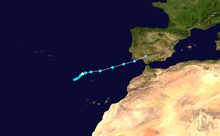
The 1842 Atlantic hurricane season featured several maritime catastrophes in the Gulf of Mexico and along the U.S. East Coast, and produced one of the only known tropical cyclones to directly affect the Iberian Peninsula.
The first documented storm of the season battered the coast of North Carolina in mid-July, wrecking dozens of ships and destroying homes along the Outer Banks.
Striking northern Florida on October 5 as the equivalent of a major hurricane, the cyclone produced extreme wind gusts to the north of its center and exceptionally high tides to the south.
The storm turned northward as it entered the western Atlantic, resulting in strong winds and flooding tides in Savannah, Georgia, and Charleston, South Carolina.
Attempts to catalog Atlantic hurricanes in the first half of the 19th century began as early as 1855, when Andrés Poey compiled information on just over 400 tropical cyclones from 1493 to 1855.
[3] In his 1963 book, Early American Hurricanes, 1492–1870, weather researcher David M. Ludlum discussed, in greater detail, six significant tropical cyclones that impacted the United States in 1842.
[6] Nearly 30 ships ran aground near Ocracoke Inlet, and two unidentified vessels were wrecked on the shoals near Cape Hatteras with all hands lost; seven more men drowned while trying to salvage goods from the shipwrecks.
[7] In late October, a message in a bottle was recovered at Bermuda with an account of the storm from the captain and first mate of the imperiled schooner Lexington, presumed lost at sea.
[7] Based on an August 2 diary entry describing heavy rainfall and gusty northeasterly winds at Fort George Island, a tropical storm is believed to have made landfall just south of there.
[11] Another damaging tropical cyclone, "hardly less severe" and reportedly of a much longer duration than the July hurricane,[9][12] struck the Outer Banks of North Carolina on August 24.
Extensive flooding in Washington, D.C. turned Pennsylvania Avenue into "a broad river" and inundated homes and cellars, with losses in the city estimated at $50,000 (1842 USD).
Streets, wharves, shipyards, and lumberyards in Baltimore were submerged, while further north, hurricane-force winds and a flooding storm surge affected New York City.
[23][24] By September 8, the cyclone had made landfall along the coast of Tamaulipas in Mexico, and the eye passed directly over Ciudad Victoria as evidenced by a brief, five-minute lull.
[25] The storm surge destroyed several structures and washed ashore small boats, while strong winds heavily damaged two churches.
For several days, the strengthening storm battered ships as it turned northeastward through the Gulf of Mexico, with numerous vessels lost and many more damaged.
[27][28] The steamship Merchant began taking on water on October 3, and the next day she broke up after running aground several hundred yards offshore.
[25] The storm buffeted Florida for an extended period from October 4 through 6,[27] and moved ashore just north of Cedar Key as the equivalent of a major hurricane on the modern-day Saffir–Simpson scale.
[33] To the south of the storm center, Cedar Key faced exceptionally high tides that swept entire homes away and threatened to submerge the island.
[10][27] At the latter city, the storm was regarded as the most severe in 15 years; fences, trees, and crops were destroyed,[35] and a few ships were driven aground, though the sea wall largely protected St.
[36] The slow-moving storm buffeted the southern Georgia Sea Islands with a prolonged period of strong winds and heavy rain, blowing down trees and destroying some houses.
No significant damage occurred,[27] though coastal flooding and heavy rainfall that caused a break in an earthen dam were reported along the coast of Georgia.