1951 Pacific hurricane season
It dissipated the next day,[1] and caused moderate flooding in southern California.
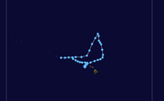
[1] A warm-core kona storm[2] transitioned into a tropical cyclone at 0000 UTC on March 21, west of the Necker Island.
At that time, the Joint Typhoon Warning Center (JTWC) began tracking the storm with winds of 30 mph (50 km/h), or tropical depression strength.
[3][4] The system weakened below tropical storm intensity as it passed through the island of Oahu.
The system made a second landfall on Oahu near Mākaha, just past 0000 UTC on March 28.
The system then sped up and made its last landfall near Kealia, just past 0000 UTC on March 29.
The JTWC[3] and the American Meteorological Society (AMS) both consider the storm to be a tropical cyclone.
Map key
Tropical depression (≤38 mph, ≤62 km/h)
Tropical storm (39–73 mph, 63–118 km/h)
Category 1 (74–95 mph, 119–153 km/h)
Category 2 (96–110 mph, 154–177 km/h)
Category 3 (111–129 mph, 178–208 km/h)
Category 4 (130–156 mph, 209–251 km/h)
Category 5 (≥157 mph, ≥252 km/h)
Unknown
Tropical storm (39–73 mph, 63–118 km/h)
Category 1 (74–95 mph, 119–153 km/h)
Category 2 (96–110 mph, 154–177 km/h)
Category 3 (111–129 mph, 178–208 km/h)
Category 4 (130–156 mph, 209–251 km/h)
Category 5 (≥157 mph, ≥252 km/h)
Unknown
Storm type