1987 Gulf Coast tropical storm
In all, losses from the unnamed storm reached $7.4 million (1987 USD) and one person was reported missing after being thrown overboard a boat in rough seas.
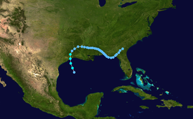
Traveling across the Caribbean, the system became increasingly organized and a mid-level circulation formed shortly before the wave moved inland over Central America on August 7.
The following day, the northern portion of the wave interacted with a cold-core low over the Gulf of Mexico, resulting in the formation of a low-level circulation, exhibiting tropical characteristics, on August 9.
Around 1200 UTC, the National Hurricane Center (NHC) estimated that the system developed into a tropical depression while located about 145 miles (235 km) south-southeast of Galveston, Texas.
[1] Hours after being classified a tropical depression, the convective structure of the system deteriorated, a sign of a weakening storm; however, nearby oil rigs indicated a gradual increase in winds.
[2] Remaining relatively weak, the unnamed system attained peak winds of 45 mph (75 km/h) before making landfall along the Texas coastline between Galveston and Beaumont at 0600 UTC on August 10.
[2] Due to the system's proximity to land upon being declared a tropical depression and subsequent intensity uncertainties, the unnamed storm posed several challenges to forecasters that "vividly illustrated limitations that are of major concern at the National Hurricane Center.
"[4] With operational forecasters noting the possibility of intensification, the first-ever tropical storm warning was issued along the northern Gulf Coast between Matagorda, Texas and Morgan City, Louisiana on August 9.
[5] By August 13, several flash flood watches were in place over portions of Mississippi, Alabama and Florida as remnants of the unnamed system slowly moved through the region.
Tropical storm (39–73 mph, 63–118 km/h)
Category 1 (74–95 mph, 119–153 km/h)
Category 2 (96–110 mph, 154–177 km/h)
Category 3 (111–129 mph, 178–208 km/h)
Category 4 (130–156 mph, 209–251 km/h)
Category 5 (≥157 mph, ≥252 km/h)
Unknown
