2006 Central Pacific cyclone
Moisture from the storm's remnants caused substantial rainfall in British Columbia and the Pacific Northwest.
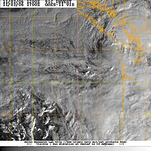
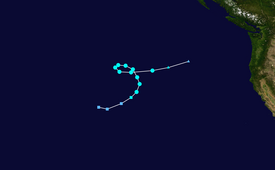
On October 28, 2006, a cut-off extratropical cyclone over the central north Pacific moved over an area of ocean with sea surface temperatures as high as 2 °C above normal, at 16–18 °C (61–64 °F), and stalled there for two days.
[1] On November 1, the system reached its peak intensity, and had estimated 1-minute sustained winds of 65 mph (100 km/h) and its most developed convection.
After that, the storm slowly weakened, looped counter-clockwise, and headed east towards the west coast of North America.
[1] On November 2, wind shear and cooler waters began to take their toll on 91C, and all convection was gone by the next day, when the storm was located roughly 520 mi (840 km) off the coast of Oregon.
[4] The National Weather Service also issued a High Wind Warning for the southern Washington coast and Northwest Oregon.
[7][8] In addition, this system's track data indicated that it crossed from the central to the east Pacific as it formed at longitude 149°W and dissipated at 135°W.
[9] Clark Evans of Florida State University reported that forecasting tools showed that the system's structure was consistent with that of a subtropical or marginally tropical cyclone.
Tropical storm (39–73 mph, 63–118 km/h)
Category 1 (74–95 mph, 119–153 km/h)
Category 2 (96–110 mph, 154–177 km/h)
Category 3 (111–129 mph, 178–208 km/h)
Category 4 (130–156 mph, 209–251 km/h)
Category 5 (≥157 mph, ≥252 km/h)
Unknown