Hurricane Daniel (2006)
Daniel gradually weakened as it entered an area of cooler water temperatures and increased wind shear, and after crossing into the Central Pacific Ocean, it quickly degenerated into a remnant low on July 26, before dissipating two days later.
Initial predictions suggested that the cyclone would pass through the Hawaiian Islands as a tropical storm; however, Daniel's remnants dissipated southeast of Hawaii.
The storm brought light to moderate precipitation to the Island of Hawaii and Maui, causing minor flooding, although no major damage or fatalities were reported.
Conditions favored development, including warm sea surface temperatures, very low amounts of wind shear, and an established anticyclone over the cyclone.
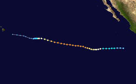
[10] It underwent an eyewall replacement cycle as it turned to the west-northwest, temporarily halting its intensification trend, before quickly strengthening and attaining major hurricane status on July 20.
It maintained peak winds for about 18 hours, and Daniel began a weakening trend as it crossed into an area of progressively cooler water temperatures.
[1] Later that day, no active convection remained near the exposed circulation center, and early on July 26, it weakened to tropical depression status.
[17] The Honolulu National Weather Service issued a high surf advisory for east facing beaches in Hawaii, and warned beachgoers to remain out of the water.
[16] West Wailuaiki on Maui recorded 3.87 inches (98.3 mm) in one day, which was the highest daily rainfall total from the hurricane.
[16] During the 61st Interdepartmental Hurricane Conference, the Hawaii State Civil Defense requested the retirement of the name Daniel, citing that it became one of the several storms memorable for threat or damage.
Tropical storm (39–73 mph, 63–118 km/h)
Category 1 (74–95 mph, 119–153 km/h)
Category 2 (96–110 mph, 154–177 km/h)
Category 3 (111–129 mph, 178–208 km/h)
Category 4 (130–156 mph, 209–251 km/h)
Category 5 (≥157 mph, ≥252 km/h)
Unknown

