2006 Pacific typhoon season
This season also featured Typhoon Ioke, the strongest Central Pacific hurricane, which also entered the basin and hit Wake Island; damages were estimated to be at $88 million.
These agencies included the Tropical Storm Risk (TSR) Consortium of University College London, PAGASA and Taiwan's Central Weather Bureau.
This is due to the observed warming of sea-surface temperatures in the Niño 3.75 region and current patterns within the Central Pacific, indicating slightly higher activity.
[6] The accumulated cyclone energy (ACE) index for the 2006 Pacific typhoon season as calculated by Colorado State University using data from the National Hurricane Center was 321.3 units.
Shortly thereafter, environments throughout most of the basin became favorable with less shear, more convection and warmer water, as three simultaneous storms, Maria, Saomai and Bopha, formed and affected three different landmasses such as Japan, China and Taiwan, respectively.
[1] On January 20, the JMA began monitoring a minor tropical depression located about 555 km (345 mi) east of Mindanao in the southern Philippines.
Traveling towards the west, the system failed to strengthen and dissipated on January 27 while located over the South China Sea, about halfway between Vietnam and Borneo.
[15] As Chanchu emerged to the South China Sea, and moved northward, the storm explosively intensified into a Category 4 typhoon and reached peak intensity with 10-minute sustained winds of 175 km/h (110 mph) on May 15.
[16][22] After crossing the archipelago and emerging into the South China Sea on June 26, PAGASA named it Domeng while the JTWC had started issuing advisories with the designation of 03W.
After moving over northern Taiwan, Bilis made landfall in Fujian, China at 12:50 p.m. CST on July 14, weakening into a tropical depression inland the next day.
Bilis brought very heavy rain, widespread flooding, landslides, and strong winds to the Philippines, Taiwan and areas of mainland China, causing 672 deaths and $4.4 billion (2006 US$) in damage.
The strong winds due to the storm resulted in 70% of flights being cancelled, delayed or diverted in the Hong Kong International Airport, the highest since the opening in 1999.
[28] On landfall in Guangdong province, China, it forced the evacuation of some 660,000 people and caused an estimated 5.4 billion Chinese yuan worth of damage.
Saomai made landfall in Zhejiang, China on August 10 with maximum sustained winds of 115 knots (1-minute mean), stronger than Chanchu earlier this season.
The outer bands of Bopha produced heavy rains over northern Luzon, triggering flooding that destroyed 1,200 homes and killed seven people.
Though never officially warned upon by any agency, meteorologist Gary Padgett and Dr. Karl Hoarau of Cergy-Pontoise University surmised that the system likely was a tropical cyclone.
Its low-level circulation then became exposed with dry air entering the system, and both the JMA and JTWC declared the storm as a dissipating tropical depression on October 6.
Rumbia slowly began to intensify while moving to the northwest, but on October 6 its low-level circulation became fully exposed, and the JTWC issued a final warning.
On October 6, a tropical disturbance formed about 240 km (150 mi) north-northeast of Kwajalein with convection nearby, developing a low-pressure area two days later.
The disturbance moved west-northwestward over the next two days and gradually became better organized, and the Joint Typhoon Warning Center issued a Tropical Cyclone Formation Alert on the system on October 26.
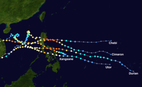
Early on November 10, the JMA upgraded Chebi to a severe tropical storm as it continued to move west towards the Philippines, following a similar track as Typhoon Cimaron earlier in the season.
Encountering dry air entrainment and increased vertical wind shear in the South China Sea, Chebi began to gradually weaken to a severe tropical storm on November 12.
A quick bout of intensification occurred on November 29, causing the JMA to upgrade the storm to 100 knots in wind intensity, and the JTWC to give it a Dvorak classification of 6.5 (127 kn) in a satellite fix.
Durian began to weaken slightly as it approached land, undergoing an eyewall replacement cycle, but quickly regained peak strength.
The storm continued to move west, making landfalls on the Bondoc Peninsula in Quezon, on Marinduque and finally on Oriental Mindoro before exiting to the South China Sea.
Encountering dry air entrainment and vertical wind shear, Durian weakened slightly at first, but slowly began to reorganise and restrengthen as it neared Vietnam.
[75] The Padang barangay of Legazpi City was severely affected with a large portion of the town covered in mud up to houses' roofs.
After crossing the Philippines, Utor took a track similar to Typhoon Chebi in November, first moving northwest then threatening to take aim at Hong Kong.
On July 28, a tropical depression had rapidly organized and persisted over in the Gulf of Tonkin and made landfall in the same location as the previous system at its peak strength with a pressure of 998 mbar.
[101] This was the same list used from the 2002 season, except for the names Domeng, Ester, Glenda, Henry, Katring, Luis, Paeng, Queenie, Reming, Seniang, Tomas, Waldo, Chito, Felino, Harriet, and Indang, which replaced Dagul, Espada, Gloria, Hambalos, Kaka, Lagalag, Paloma, Quadro, Rapido, Sibasib, Tagbanwa, Wisik, Ciriaco, Forte, Hunyango, and Itoy, respectively.