2013–14 North American winter
Due to the polar vortex phenomenon, a majority of the United States had one of their coldest and snowiest years on record, particularly in cities east of the Mississippi River, as a result of several storms taking a favorable path through the Northeast and along the coastline, supplied by plentiful cold air.
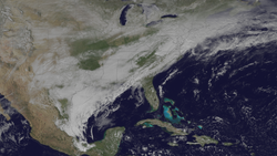
Additionally, arctic air plunged south enough that areas along the Gulf Coast of the United States experienced wintry precipitation, which is a rarity and left many citizens unprepared there as a result.
Collectively, the wintry weather resulted in approximately 134 deaths in total across the continent, with damage estimated to be over US$5 billion (2014 USD).
On November 21, 2013, the National Oceanic and Atmospheric Administration's Climate Prediction Center issued its U.S. Winter Outlook.
Some of the mountainous areas received nearly 4 feet (48 in; 120 cm) of snow along with gusty winds creating blizzard conditions, while a significant tornado outbreak occurred further southeast in the warm sector.
[5] Afterwards, little activity occurred until mid-November, where an arctic front brought the first snowfall and cold temperatures to much of the Northeastern United States.
[8] The storm occurred as an early season blizzard, and, according to the Weather Prediction Center, was an event of a magnitude unseen for the past decade.
[10] Mixed precipitation developed ahead of an occluded front that was attached to the low, causing impacts across the Western United States.
[10] A southerly low-level jet across the Southeastern United States pulled moisture into the East Coast of the United States, and, with the combination of the phased upper-level low and the moisture drawn from the southerly low-level jet, broadened a precipitation shield northeastward.
[22] On December 1, 2013, the weakening of the polar vortex led to the beginning of an abnormally cold trend in the Eastern and Central United States.
[29][30][31][32] The cold blast led to a monthly average temperature of only 7.5 °F (−13.6 °C) in Rhinelander, Wisconsin, the 8th coldest December for the state on record.
[39][40][41] 2014 began on an active note, with another major winter storm affecting much of the United States on January 6–7, days after the previous blizzard.
Between 6 and 12 inches (150 and 300 mm) of snow fell with this system across a wide area spreading from central Missouri across Illinois and Indiana to Lower Michigan.
Snowfall totals of near 18 inches (460 mm) were recorded across northern Indiana, and additional accumulations occurred downwind from the major Great Lakes.
Upper flow which was meridional all the way up to the Arctic Circle provided a direct path for cold air advection to occur southward to the United States.
The event was short-lived, with the portion of the polar vortex that had traveled across the Great Lakes lifting northeastward into Quebec soon after.
Then, as it neared the coast, a new area of low pressure developed off the Outer Banks and began to move northwards, as snowfall expanded into parts of the Mid-Atlantic; consequently, by 15:00 UTC on January 21, the Weather Prediction Center (WPC) initiated storm summary bulletins for the developing winter storm.
The system, which was not well-forecast in advance and was stronger than anticipated by many, also struck at or near rush hour, which created hazardous conditions and impacts from Washington D.C. to Boston, Massachusetts.
In the wake of the storm, bitterly cold temperatures pushed into the Northeast once again, causing dangerously low wind-chills.
As the southern stream trough axis weakened while it moved eastward across the western Gulf of Mexico, a northern stream trough amplified as it headed toward the Southeastern U.S. Overrunning wintry precipitation affected the area as a weak surface low traveled along the front and crossed into the Atlantic.
It then quickly moved offshore by roughly 3 p.m.[50] This part of the storm was only the beginning of a crippling 2-day streak of winter nightmares across the South.
Later on February 11, another area of low pressure formed on the extreme southern edge of the Gulf Coast, near the TX–LA border.
As it tracked eastward, it began to interact with the cold air above it, producing an area of ice and snow on its backside as it moved to the east.
Meanwhile, to the south, near the Gulf Coast, heavy showers and thunderstorms were consisted in a streak of rain stretching up to southern parts of Georgia.
[51] Early on February 13, more snow began to develop on the northern side of the storm as the precipitation shield approached the New York metropolitan area in colder air.
Even though the area of low pressure, which had now deepened to 988 millibars (29.2 inHg)[52] late on February 13, was offshore of the East Coast, little to no precipitation was falling as a result of dry air to funnel its way into the storm.
Late on March 2, snow and ice began to develop along a weak area of low pressure near Texas and Oklahoma.
Numerous locations reported thunderstorms with sleet and freezing rain due to the intense upper-air dynamics and Arctic air at the surface.
On March 29, the system deteriorated into a weak winter storm over Greenland, where it would remain for the next few days while slowly dissipating.
[60][61][62] The first week of March 2014 also saw remarkably low temperatures in many places, with 18 states setting all-time records for cold.