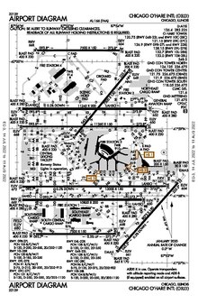
Airport diagram
[3] According to ICAO, airport diagrams shall show coordinates, field elevations, runways, aprons, taxiways, hot spots, taxiway routes, air transit routes, lighting, air traffic control (ATC) service boundary, communication channels, obstacles, slope angles, buildings and service areas, VOR checkpoints, and movement area permanently unsuitable for aircraft.
[5] A hot spot is a location on an airport movement area with a history or potential risk of collision or runway incursion, and where heightened attention by pilots and drivers is necessary.
[8] If pilots study the diagram prior to their arrival or departure, they can expect what runway to use and routes to take while navigating around a complex airport.
For pilots who were unable to establish radio communication with ATC, the diagram shows where the control tower is and hence where light signals may come from.
[5] In the United States, airport diagrams are published as part of Terminal Procedures Publication and are updated every 56 days unless there is a critical safety issue.