Terminal area chart
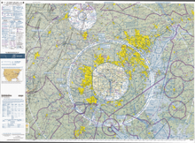
In United States and Canada aviation, terminal area charts are aeronautical charts intended for navigation under Visual Flight Rules that depict areas surrounding major airports, primarily those with Class B airspace.
Like the VFR sectional charts that they complement, terminal area charts depict topographic features and other information of interest to aviators flying visually, including major landmarks, terrain elevations, visual navigation routes, ground-based navigation aids, airports, rivers, cities, and airspace boundaries.
TACs contain information on approach, departure, and transition rules and procedures for the congested Class B areas around major airports.
The reverse side of a paper copy of the TAC often provides a flyway chart, a simplified chart that shows preferred VFR routes through the area covered by the TAC.
TACs are updated every 56 days and historically were called local aeronautical charts.