Alphabet City, Manhattan
The neighborhood has a long history, serving as a cultural center and ethnic enclave for Manhattan's German, Polish, Hispanic, and immigrants of Jewish descent.
[6] Stuyvesant Town, a post–World War II private residential development, blotted out the rest of A and B above 14th Street (sparing only a few blocks of Avenue C).
[7][8] However, sociologist Christopher Mele connects the term to the arts scene of the late 1970s which in turn attracted real estate investors.
"[14] Similarly, a November 1984 article in The New York Times reported "Younger artists ... are moving downtown to an area variously referred to as Alphabetland, Alphabetville, or Alphabet City (Avenues A, B, C and so forth on the Lower East Side of Manhattan).
[16] It also appeared in The New York Times in an April 1984 editorial by Mayor Ed Koch justifying recent police operations: The neighborhood, known as Alphabet City because of its lettered avenues that run easterly from First Avenue to the river, has for years been occupied by a stubbornly persistent plague of street dealers in narcotics whose flagrantly open drug dealing has destroyed the community life of the neighborhood.
That's because calling it "Alphabet City" brings too many memories of the days when outsiders began coming to Avenues A, B, C and D for the galleries, the clubs and the drugs.
[19]Several local nickname sets associated with the ABCD denotation have included Adventurous, Brave, Crazy and Dead and, more recently by writer George Pendle, "Affluent, Bourgeois, Comfortable, Decent".
[27] In 1625, representatives of the Dutch West India Company set their sights on lower Manhattan, with plans for a fortified town at its tip served by farms above.
[32] In his influential Description of New Netherland (1655), Adriaen van der Donck informed his fellow Dutchmen: There [are] salt meadows; some so extensive that the eye cannot oversee the same.
[34] Stuyvesant and his heirs, with the help of slave labor, continued to occupy their farm as a country estate, cultivating it lightly and making few changes to the land.
The commissioners wrote: "The place selected for this purpose is a salt marsh, and from that circumstance, of inferior price, though in regard to its destination, of greater value than other soil.
In 1823, a newly created committee, with latitude to amend the 1811 plan, proposed to save money with a network of closed sewers, but these suffered a bad reputation from repeated clogging in older parts of the city.
Archaeological excavations along Avenue C at 8th Street show that the site was incrementally raised 10–12 feet between 1820 and 1840, occupied from the 1840s (with the aid of a private cistern), and only drained by the proposed sewer line in 1867.
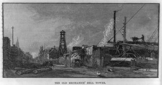
Shipyards tended to form tight clusters in close proximity to specialized workers, such as ship carpenters, and ancillary manufacturers, such as iron works.
[68] After the Civil War, land and labor costs, along with the switch from wood to more massive iron hulls, would push the industry off the island entirely.
[80][c] In 1828, an observer wrote, "No place on this island has the destroying hand of man done more to alter the face of nature... Hills of great magnitude have been entirely levelled, or cut down, and used to fill up docks and wharves.
[102] By the early 1840s, shipyard owners dotted the neighborhood,[103] and the majority of the city's ship carpenters lived in a narrow strip of blocks along Avenue D and Lewis Street, a stone's throw from the wharfs.
Sean Wilentz, who documented the sweatshop proclivities of antebellum New York City, points to shipbuilding as the rare industry where tradition persisted and kept wages, skill and respect generally high.
[115] Rowhouses of 2.5 to 3 stories were built on the side streets by such developers as Elisha Peck and Anson Green Phelps; Ephraim H. Wentworth; and Christopher S. Hubbard and Henry H.
[122] To address concerns about unsafe and unsanitary conditions, a second set of laws was passed in 1879, requiring each room to have windows, resulting in the creation of air shafts between each building.
[132] This included groups of Italians and Eastern European Jews, as well as Greeks, Hungarians, Poles, Romanians, Russians, Slovaks and Ukrainians, each of whom settled in relatively homogeneous enclaves.
[133] The Roman Catholic Poles as well as the Protestant Hungarians would also have a significant impact in the East Side, erecting houses of worship next to each other along 7th Street at the turn of the 20th century.
[144] Latin American immigrants started to move to the East Side, settling in the eastern part of the neighborhood and creating an enclave that later came to be known as Loisaida.
[157] These included the Pyramid Club, which opened in 1979 at 101 Avenue A; it hosted musical acts such as Nirvana and Red Hot Chili Peppers, as well as drag performers such as RuPaul and Ann Magnuson.
[159] However, as early as 1983, the Times reported that because of the influx of artists, many longtime establishments and immigrants were being forced to leave the area due to rising rents.
About half of Alphabet City's stores had opened within the decade since the riot, while vacancy rates in that period had dropped from 20% to 3%, indicating that many of the longtime merchants had been pushed out.
An archive of urban activism, the museum explores the history of grassroots movements in the East Village and offers guided walking tours of community gardens, squats, and sites of social change.
[172] In early 2011, the New York City Landmarks Preservation Commission (LPC) proposed a small district along the block of 10th Street that lies north of Tompkins Square Park.
Originally coined by poet/activist Bittman "Bimbo" Rivas in his 1974 poem "Loisaida", it now refers to Avenue C in Alphabet City, whose population has largely been Hispanic (mainly Nuyorican) since the 1960s.
Manhattan's growing Chinatown then expanded into the southern portions of the Lower East Side, but Hispanics are still concentrated in Alphabet City.