Ammergau Alps
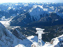
There are just two cable cars on the northern perimeter - the Tegelberg and Laber Bergbahn - and three chair lifts: to the Buchenberg, Hörnle and Kolben Saddle.
The border between the Bavarian provinces of Upper Bavaria and Swabia, which is also the county boundary between Garmisch-Partenkirchen and Ostallgäu, runs from south to north through the Ammergau Alps.
Generally dolomite underlies the whole southern section of the range with the exception of small pockets of plattenkalk, which is why it has a relatively monotone topography.
Near the edge of the Alps, however, flysch appears over wide areas (Hohe Bleick, Hörnle) and, because of its susceptibility to erosion, forms rounded, frequently densely wooded mountains more typical of the Central Uplands.
One unusual topographic feature is the Kessel, a large doline funnel in the area of the Hasentalkopf, that was deepened as a result of the loosening of rock.
The ecology of the region is important because of the constant shifting of the Griese, the dolomitic screes, because this dynamic supports the existence of rare plants.
In the Friedergries, for example, the rare Spirke tree grows, a species exclusively dependent on frequent movements of scree.
Certain woodland communities are also very valuable such as the unique boulder and ravine and forests or coloured reed grass and pine woods.
At around two dozen boggy depressions in the Ammergau Alps, Alpine mountain pine raised bogs are excavated and supplied to the spa facilities and "wellness" hotels in the region.
In many areas (e.g. on the Friederspitz), intensive grazing of sheep has caused problems as a result of the destruction of grassy alpine mountainside by erosion.
This is due to the fact that large parts of the Ammergau Alps were a royal hunting area and also that dolomite and flysch soils create unsuitable conditions for alm and grassland cultivation.
The Loisach borders the Ammergau Alps in the east, southeast and south from its exit into the Alpine Foreland upstream as far as the Ehrwald Basin.
The Violet Way of the Via Alpina has 3 stages and runs through the range as follows: In the valleys between Unterammergau, Oberammergau, Ettal and Schloss Linderhof there are numerous loipes with a high likelihood of snow in winter.