Lechquellen Mountains
Nevertheless, it is in fact an artificial name made up by Walther Flaig at a time when the development of mountaineering in the Alps had been largely completed.
By contrast, there are Alpine groups named after placenames that go back centuries or even millennia, such as the Raetikon or the neighbouring Verwall.
It is also unclear whether the UIAA or even the European Union will work out and lay down an internationally recognized classification of the Alps.
The southern boundary of Lechquellen Mountains runs from the alpine town of Bludenz along the Klostertal to the Flexen Pass.
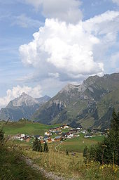
From there, it runs along the Seebach via the village of Schröcken and continues along the Bregenzer Ach stream up to Au and its confluence with the Argenbach.
Walther Flaig, a well-known alpine guide and author from Vorarlberg, had a significant influence on the definition and extent of the Lechquellen Mountains.
The name he gave to the mountains and his definition of their extent was included in the Alpine Club classification of the Eastern Alps (AVE).
Its power is supplied by hydroelectricity from the overflow of the Spullersee, which lies at a height of 700 metres above the Klostertal valley in the southern part of the Lechquellen mountains.
As a result, these core zones already present today the image of natural mountainous (virgin) forests with trees of different age classes and a high proportion of dead-wood in the Northern Limestone Alps.