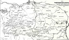
Wetterstein
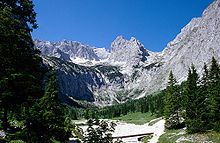
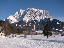
It is a comparatively compact range located between Garmisch-Partenkirchen, Mittenwald, Seefeld in Tirol and Ehrwald along the border between Germany (Bavaria) and Austria (Tyrol).
The proximity of the range to the south German centres of population, the scenic landscape and its good network of cable cars and lifts mean that the mountains are heavily frequented by tourists for most of the year.
The saddle between the Kankerbach and the Kranzbach (the Loisach – Isar watershed) links the Wetterstein with the Bavarian Prealps.
The climbing along the Blassenkamm ridge over the tops of the Innere, Mittlere and Äußere Höllentalspitze has sections that are classified as UIAA grade III-.
The region around the Oberreintal Hut and the south side of the Schüsselkarspitze and Scharnitzspitze are well known for alpine climbing routes of all levels up the solid, limestone slabs.
In addition, are the privately run Schachenhaus (1,866 m) and the Wiener Neustädter Hut (2,209 m, maintained by the Austrian Tourist Club) offer food, refuge and accommodation for mountaineers and hikers.
Of these, the Kreuzjochhaus stands out because of its idyllic setting, which offers one of the best panoramas in the Bavarian Alps in the summer and is located in the middle of the Garmisch-Partenkirchen ski region in the winter.
The high alpine variant runs via the Meiler Hut into the Reintal valley and continues to the summit of the Zugspitze.
For many years there were discussions about a project to build a railway tunnel between the Tyrolean village of Telfs and the Bavarian town of Garmisch-Partenkirchen.