Ancient bridges over the Loire in the Touraine area
The ancient bridges over the Loire in the Touraine area were wooden structures erected during the Roman Empire to facilitate river navigation close to Fondettes and Tours, then known as Caesarodunum.
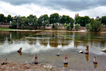
[Tam 4] In 1987, constructing a channel for a windsurfing competition destroyed the majority of these remains, leaving only a few stakes situated near the northern bank.
The sparse remains, studied in 2003, permit the reconstruction of a wooden bridge that connected a valley on the northern bank of the river to Caesarodunum.
This hypothesis is corroborated by the discovery of a masonry structure south of the modern quay, interpreted as the abutment of this ancient bridge during excavations conducted between 2000 and 2003.
[Tam 5] Furthermore, in addition to the aforementioned remains, a north-south road was unearthed in the vicinity of a substantial temple [fr] and a thermal complex, situated to the south of the ancient city.
[Tam 7] The bridge, abutment, and road collectively constitute a north-south axis extending into the city and serving multiple public edifices.
[Tam 8] The "Île Saint-Jacques" Bridge, with a length of approximately 560 meters, was constructed between 40 and 60 AD and subsequently underwent regular repairs until the mid-2nd century.
[Tam 10] In 1978, the lowering of the Loire's water level revealed a series of stakes embedded in the riverbed, extending from the upstream side of Île Aucard [fr], situated in the eastern part of Tours, towards the southern bank.
In 1985, the hypothesis of a bridge crossing the Loire in the Late Roman Empire was proposed, but natural changes in the riverbed prevented further observations.
[Tam 9] The alignment of the stakes suggests the presence of a bridge with a length of at least 270 meters, whose rectangular piers supported a wooden deck.
[12] The entire setup served as a mechanism to control access to the Loire River by forcing passage through the fortifications and regulating arrivals from the northern bank.