Meola Reef
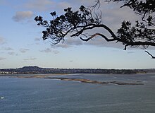
The reef extends for over 2 kilometres across the harbour, to within 500 metres of Kauri Point on the northern shore.
[2][3] The reef was formed more than 28,000 years ago from the final portion of an 11 kilometre lava flow that originated from Mount Saint John volcano.
[4] Located between the Point Chevalier and Westmere suburbs and protecting the calm waters of Coxs Bay, the reef is easily seen in the west from the Auckland Harbour Bridge at low tide, when much of it lies exposed.
[6] This has now been capped[7] and replaced by a 15 ha public reserve, with mangrove swamps in the streams and tidal salt marshes either side.
Since its establishment as a reserve, much of the Meola Reef became a fully fenced off-leash dog park.