B4329 road
[6][7] Before that, when most journeys were made on foot, horseback or horse-drawn vehicle, travellers were provided for by inns along the route, such as those at Crosswell, Tufton, Greenway and Crundale.
[10] In winter, the highest parts of the road can occasionally be closed when ice or snow make driving conditions dangerous.
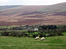
[12] The road enters the Pembrokeshire Coast National Park,[6] crossing another narrow bridge, Pont Saeson, then climbs steadily through farmland, passing a Grade II-listed 19th century circular stone structure for impounding livestock that had strayed from the mountains.
From Brynberian, the gradient increases until the road reaches 284 metres (932 ft) at Tafarn-y-Bwlch (approximate English: Tavern at the Pass), an inn which existed at least as early as 1729,[15] and still sustaining travellers as late as 1895.
[17] Immediately after the inn, the road crosses a cattle grid marking a boundary between enclosed agricultural land and unenclosed moorland and continues to climb, reaching 404 metres (1,325 ft) between Cerrig Lladron and Mynydd-du Commin.
[18] At the summit the B4329 meets the western end of the elevated track that runs from Mynachlog-ddu along the top of the range and is known as Flemings' Way[15] or alternatively the Golden Road.
[19] After the summit, Bwlch-gwynt (translation: windy gap), the road drops steeply to another cattle grid and the intersection with the B4313 at New Inn which, according to Richard Fenton in the 19th century, sustained northbound travellers before "the arduous task of winding up the painful ascent of Bwlch Gwynt".