Beaverdam Creek (conservation area)
[1][2] Located on upper Holston Mountain, the area is bordered by Beaverdam Creek, a trout stream that is home to the hellbender, one of the largest salamanders in the world.
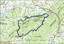
[4][5][6] Road access to the area in the Cherokee National Forest is provided by routes 295 A, B and C.[4] The boundary of the wildland as determined by the Wilderness Society is shown in the adjacent map.
The Appalachian Mountains were extensively timbered in the early twentieth century leaving logging roads that are becoming overgrown but still passable.
[7] Old logging roads and railroad grades can be located by consulting the historical topographic maps available from the United States Geological Survey (USGS).
The Beaverdam Creek wild area is covered by USGS topographic maps Shady Valley, Laurel Bloomery and Damascus.
Geologic rock types are the Erwin Formation with white, vitreous quartzite, interbeds of dark-green, silty and sandy shale, minor siltstones and very fine sandstone; the Hampton Formation with dark greenish-gray, silty and sandy shale, micaceous shale, numerous layers of medium-grained, feldspathic, and thinly bedded sandstone; the Union Formation, a sequence of grey feldspathic sandstone, arkose, conglomerate, greywacke, siltstone and shale, and greenish amygdaloidal basalt flow; and Shady Dolomite, a light gray, well-bedded dolomite with thin to medium-bedded gray limestone, and yellowish brown residual clays with "jasperoid" diagnostic.
The rule provided some degree of protection by reducing the negative environmental impact of road construction and thus promoting the conservation of roadless areas.
The area in Tennessee is divided into three parts: "Remote Backcountry-Non-motorized", "Black Bear Habitat Management" and "Appalachian Trail Corridor".