Flat coast
Flat coasts can be formed either as a result of the sea advancing into gently sloping terrain or through the abrasion of loose rock.
The littoral series of a flat coast starts in the permanently flooded shallow water region, or shoreface, with a sand or gravel reef (also called a bar).
The longshore bar is an elongated ridge of sand found parallel to the shore in the surf zone on many flat coasts.
The shoreface (or underwater platform) on flat coasts encompasses in its narrow sense that area which is subject to the constant action of moving water.
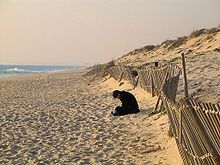
Whilst some define the beach as the landward transition to the shoreface that extends from the low-water mark to the highest high-water mark, i.e. the zone that is only periodically or episodically (after a storm surge) flooded by water; other authors do not use the term "beach" for the landward element of a flat coast at all.
A striking example of land-forming system of berms is Skagen Odde on the northern tip of Vendsyssel in the extreme north of Denmark.
The first plants to colonise the dunes include sea buckthorn or beach grass which prevent wind erosion.