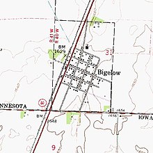
Bigelow, Minnesota
[4] According to the United States Census Bureau, the city has a total area of 0.40 square miles (1.04 km2), all land.
Main highway is: Other important transportation: Beginnings: The town of Bigelow was the third community to come into existence in Nobles County.
Throughout the summer of 1872, the site was occupied only by a large tent which furnished shelter for the construction crew.
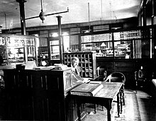
A railroad depot was constructed in September 1872, and Mr. S. O. Morse assumed duties as station agent.
He went into partnership with a man named Frothingham, and the two established a small grocery store in the depot.
[6] He was also a director of the St. Paul & Sioux City Railway, and the board decided to flatter him by naming a new town after him.
There is no record of Charles Bigelow visiting the town that bears his name, though it is likely he passed through on the railroad that he helped to create.
(One must assume that many of the 24 students enrolled in the Bigelow school resided on farms outside of the village.)
Charles L. Davidson, of Hull, Iowa, purchased the townsite on January 25, 1892, and decided to "boom the town", or attract investment and settlers.
On February 13, 1900, an election was held, and by a vote of 37 to 6 it was decided that the time had come for municipal government.
In recent years, Minnesota State Highway 60, which once passed directly through town, was widened to four-lanes, and bypassed Bigelow entirely.
The racial makeup of the city was 92.64% White, 0.43% Native American, 0.87% Asian, 6.06% from other races.
Bigelow is located in Minnesota's 1st congressional district, represented by Jim Hagedorn, a Republican.
City Council members are Terry Neugebauer, Robert Paplow, Brad Meester, and Ryan Weber.