Brisbane River
John Oxley, the first European to explore the river, named it after the Governor of New South Wales, Sir Thomas Brisbane in 1823.
The river is a tidal estuary and the water is brackish from its mouth through the majority of the Brisbane metropolitan area westward to the Mount Crosby Weir.
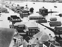
In 1974, the most damaging flood on record occurred, causing the 66,000-tonne vessel Robert Miller (largest ship ever built on the river) to break free from its mooring.
In 1823 John Oxley named the river after the Governor Thomas Brisbane while surveying the area to locate a new penal settlement.
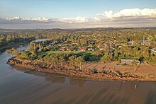
Using an alternative modern definition, the source is located at the top of Fig Tree Gully in the Bunya Mountains, which are the headwaters of the river's longest tributary Cooyar Creek.
[44] Four European navigators, namely James Cook, Matthew Flinders, John Bingle[45] and William Edwardson,[46] all visited Moreton Bay but failed to discover the river.
He spent a total of 15 days in the area, touching down at Woody Point and several other spots, but failed to discover the mouth of the river although there were suspicions of its existence.
This is consistent with accounts of many other rivers along the east coast of Australia, which could not be found by seaward exploration but were discovered by inland travellers.
John Oxley was Surveyor General of New South Wales when, in the same year and under orders from Governor Brisbane, he sailed into Moreton Bay looking for a suitable new site for a convict settlement to be established.
An entry in Oxley's diary on 19 November 1823 describes his surprise meeting with one of the shipwrecked men: By that time Pamphlett and Finnegan were living with natives near Bribie Island.
On 2 December 1823, Oxley and Stirling, with Finnegan as a somewhat reluctant guide, entered the river and sailed upstream as far as present-day Goodna.
[52] Reports by early European explorers such as Allan Cunningham and Oxley indicate rainforest once fringed the Brisbane River and its major tributaries, especially on the broader floodplains such as St Lucia and Seventeen Mile Rocks.
Upon the establishment of a local settlement in 1824, other explorers such as Allan Cunningham, Patrick Logan and Major Edmund Lockyer made expeditions and surveys further upstream, and, in May 1825, the Moreton Bay penal colony at Redcliffe under the command of Heny Miller relocated to North Quay.
In February 1896, one of the river's worst disasters occurred with the capsize of the ferry Pearl (which struck the anchor chain of the government yacht Lucinda) with the loss of around 40 lives.
[53]: 6 On 25 March 1941, a USA goodwill flotilla arrived in the city docking at wharves along the River and built Naval Base Brisbane.
In 1977, Queen Elizabeth II switched on the Jubilee Fountain positioned in front of the proposed Queensland Cultural Centre.
Past floods have resulted in both deepening and reduction in river depth, creation of new sand banks and shoals as well as increased transport of suspended sediment from upstream.
Before the invention of modern dredging techniques the sediment deposited by flooding created hazards to ships navigating the river.
Thus higher than normal flows cause river levels to rise rapidly and once the top of the banks are breached the floodwaters can spread over wide areas of the city.
[50]: 192 By early 1825 buoys were being laid along the South Passage and shortly after that the first pilots were commissioned to guide ships entering from Moreton Bay and another service for those travelling upstream.
For navigation and safety reasons the Seventeen Mile Rocks were completely removed in 1965 after numerous partially successful attempts in the past.
More recently, extensive facilities for the Port of Brisbane have been constructed on Fisherman's Island which has also seen significant land reclamation into the bay.
Historically, the Brisbane River contained upstream bars and shallows and had a natural tidal limit of only 16 km (10 mi).
[71] Early in the morning of 13 January 2011 a several hundred metre long section of the Riverwalk broke away from the main structure and floated downstream.
[76] The lower reaches received a very poor rating in the 2008 Healthy Waterways report, an annual assessment of river water quality.
[57] The major causes of pollution are excess nutrients, hydrocarbons, pesticides and bacteria which become concentrated in the river and its sediment after flowing off surrounding lands.
[81] In 2019, research at the University of Queensland indicated that the river's turbidity cycle (and murky brown colour) is principally driven by exchanges of mud between the channel and mudbanks.
However, by planting Crinum pedunculatum in a line parallel to the channel and below the mean water level, the turbidity would reduce to such a degree that the river would appear clear and blue.
[85][86] The Brisbane River is home to a very large population of bull sharks, thus swimming is not advised due to the dangers imposed by this predatory fish.
Riverfire, which began in 1998, was a festival held in September each year at South Bank Parklands and surrounding areas (including the Victoria Bridge), to celebrate the Brisbane River.

Legend