Vale of Glamorgan
It borders Bridgend County Borough to the west, Cardiff to the east, Rhondda Cynon Taf to the north, and the Bristol Channel to the south.
In medieval times, the village of Cosmeston, near what is today Penarth in the south east of the county, grew up around a fortified manor house constructed sometime around the 12th century by the De Costentin family.
[3] The De Costentins, who originated on the Cotentin peninsula in northern France,[4] were among the first Norman invaders of Wales in the early 12th century following William the Conqueror's invasion of neighbouring England in 1066.
[10] Located immediately to the west of Cardiff between the M4 motorway and the Severn Estuary, the county borough of Vale of Glamorgan covers 33,097 hectares (130 square miles) and has 53 km (33 mi) of coastline.
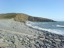
The rocks were formed between 360 and 200 million years ago when the whole area lay underneath a warm, shallow sea at the start of the Jurassic period.
The Liassic limestone and Carboniferous Limestone are also used in the Vale as building materials; in previous centuries it was taken by sloops across the Bristol Channel to North Cornish ports such as Bude, Boscastle and Port Isaac to fertilise Cornwall's poor slate soils; the hard Devonian slate was brought back from Cornwall as a roofing material for houses in the Vale.
As the Glamorgan Heritage Coast faces westwards out to the Atlantic, it bears the brunt of onshore (westerly and south-westerly) winds: ideal for surfing, but a nuisance for ships sailing up the Bristol Channel to Cardiff.
As in North Cornwall and South-West Ireland, the fierce Atlantic gales created ideal conditions for deliberate shipwrecking, which until 100 years ago was very common along the coast.
[citation needed] Nash Point, Southerndown and Ogmore-by-Sea have some of the highest shipwreck victims on the coast of Wales; as recently as 1962 an oil tanker, the BP Driver, crashed into Nash Point during a violent westerly storm, was torn to shreds by the reefs and eventually sank, although the crew were saved by various Bristol Channel lifeboats and helicopters.
[14] The Vale of Glamorgan was determined to be the wealthiest area in Wales in a 2003 survey conducted by Barclays Bank that measured disposable income.
[15] Chemical industries are located to the east of the port of Barry[16] while further inland the main activity is agriculture, especially beef and dairy cattle, with marketing facilities at Cowbridge.
[20] There are several other smaller football clubs in the county such as Llantwit Major F.C., established in 1962,[21] which competes in the Cymru South,[22] and Penarth Town AFC in the Vale of Glamorgan League.
The M4 is economically important to the county borough as it "facilitates the movements of goods and people" from the region to other areas of the UK, enabling local firms "access to domestic and international markets."
All services on the line are operated by Transport for Wales, linking the Vale directly to other areas of the capital region, including Cardiff Queen Street, Pontypridd, and Merthyr Tydfil.
The nearest stations on the South Wales Main Line are (from east to west): Cardiff Central; Pontyclun; Llanharan; Pencoed; Bridgend.