Cameroon–Chad border
[2] The process culminated in the Berlin Conference of 1884, in which the European nations concerned agreed upon their respective territorial claims and the rules of engagements going forward.
As a result of this France gained control of the upper valley of the Niger River (roughly equivalent to the areas of modern Mali and Niger), and also the lands explored by Pierre Savorgnan de Brazza for France in Central Africa (roughly equivalent to modern Gabon and Congo-Brazzaville).
[2] From these bases the French explored further into the interior, eventually linking the two areas following expeditions in April 1900 which met at Kousséri in the far north of modern Cameroon.
[2] France and Germany established the rough delimitation of their respective spheres of influence in the region in December 1885, with a more precise boundary agreed upon in 1894.
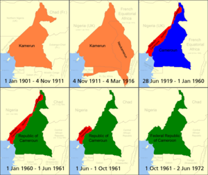
[2] On 22 June 1922 Cameroon became a League of Nations mandate, with the vast majority of the colony going to France, and smaller areas along the Nigerian border in the west to Britain.