Canutama State Forest
[1] The state forest lies on the left (west) bank of the Purus River between the towns of Canatuma and Nova Ação.
[4] The conservation unit was created with five others totalling 23,000 square kilometres (8,900 sq mi) to help meet the requirements for granting an environmental license to reconstruction work on the BR-319 highway that connects Porto Velho to Manaus.
The minister of the environment defended implementation of what he called a "green pocket" around the highway.
[3] On 16 November 2009 the forest was recognised as supporting 200 families of small rural producers, who would be eligible for PRONAF.
[5] In December 2012 the Amazonas state government allocated more than R$6 million to these nine units, covering 30,000 square kilometres (12,000 sq mi) and 143 communities, to be coordinated by the State Center for Conservation Units (CEUC).
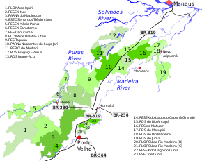
7 . Canutama State Forest