Surveying
Surveyors work with elements of geodesy, geometry, trigonometry, regression analysis, physics, engineering, metrology, programming languages, and the law.
In ancient Egypt, a rope stretcher would use simple geometry to re-establish boundaries after the annual floods of the Nile River.
The almost perfect squareness and north–south orientation of the Great Pyramid of Giza, built c. 2700 BC, affirm the Egyptians' command of surveying.
[4] The mathematician Liu Hui described ways of measuring distant objects in his work Haidao Suanjing or The Sea Island Mathematical Manual, published in 263 AD.
Leonard Digges described a theodolite that measured horizontal angles in his book A geometric practice named Pantometria (1571).
They included a re-surveying of the meridian arc, leading to the publication in 1745 of the first map of France constructed on rigorous principles.
At the beginning of the century, surveyors had improved the older chains and ropes, but they still faced the problem of accurate measurement of long distances.
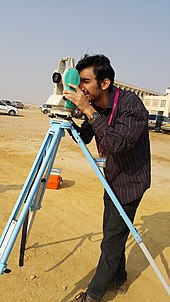
The main surveying instruments in use around the world are the theodolite, measuring tape, total station, 3D scanners, GPS/GNSS, level and rod.
When beginning the survey, the surveyor points the instrument in a known direction (bearing), and clamps the lower plate in place.
[10] Modern top-of-the-line total stations no longer need a reflector or prism to return the light pulses used for distance measurements.
The productivity improvements from a GPS on large scale surveys make them popular for major infrastructure or data gathering projects.
One-person robotic-guided total stations allow surveyors to measure without extra workers to aim the telescope or record data.
[12] Surveyors use ancillary equipment such as tripods and instrument stands; staves and beacons used for sighting purposes; PPE; vegetation clearing equipment; digging implements for finding survey markers buried over time; hammers for placements of markers in various surfaces and structures; and portable radios for communication over long lines of sight.
[14] Other computer platforms and tools commonly used today by surveyors are offered online by the U.S. Federal Government and other governments' survey agencies, such as the National Geodetic Survey and the CORS network, to get automated corrections and conversions for collected GPS data, and the data coordinate systems themselves.
The plane table provided a graphical method of recording and measuring angles, which reduced the amount of mathematics required.
This forms a reference or control network where each point can be used by a surveyor to determine their own position when beginning a new survey.
Survey points are usually marked on the earth's surface by objects ranging from small nails driven into the ground to large beacons that can be seen from long distances.
Sometimes a tall, distinctive feature such as a steeple or radio aerial has its position calculated as a reference point that angles can be measured against.
Since the early days of surveying, this was the primary method of determining accurate positions of objects for topographic maps of large areas.
The measurements could then be plotted on a plan or map, and the points at the ends of the offset lines could be joined to show the feature.
Most traverses form a loop pattern or link between two prior reference marks so the surveyor can check their measurements.
The simplest coordinate systems assume that the Earth is flat and measure from an arbitrary point, known as a 'datum' (singular form of data).
[18] In geodetic surveying the curvature of the Earth is taken into account while calculating reduced levels, angles, bearings and distances.
Surveyors help determine the placement of roads, railways, reservoirs, dams, pipelines, retaining walls, bridges, and buildings.
They also provide advice and data for geographical information systems (GIS) that record land features and boundaries.
The largest institution is the International Federation of Surveyors (Abbreviated FIG, for French: Fédération Internationale des Géomètres).
The Royal Institution of Chartered Surveyors (RICS) is a world-recognised governing body for those working within the built environment.
A quantity surveyor can work for either the client or the contractor, and can be involved in different stages of the project, from planning to completion.
George Washington and Abraham Lincoln surveyed colonial or frontier territories early in their career, prior to serving in office.
Percy Harrison Fawcett was a British surveyor that explored the jungles of South America attempting to find the Lost City of Z.