Cherokee County, Georgia
[4] The discovery of gold in local streams accelerated the push of European Americans to expel the Cherokee from their land.
[5] The forcible removal of the Cherokee people to Indian Territory west of the Mississippi River began during this year.
Cherokee County began to see rapid population growth following the construction of Interstate 575, the first phase of which opened in 1979.
The freeway bisects the county and serves as its primary thoroughfare, running from Kennesaw north through Woodstock, Holly Springs, Canton, and Ball Ground.
The lake is fed by the Etowah and Little Rivers (the county's primary waterways), and other large streams such as Noonday Creek.
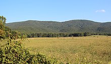
[8] Nine summits are listed by the United States Geological Survey Geographic Names Information System as being in the county.
Having consistently followed a Solid South voting pattern for the bulk of the late 19th century and again from the Great Depression through the Civil Rights Movement, the most recent Democratic presidential candidate to win Cherokee County is Georgian Jimmy Carter, who carried it in both of his bids.
[9] The GOP margin of victory has decreased in the past three presidential cycles as population growth has led Metro Atlanta and, in turn, the state as a whole to shift politically leftward.
Thus, members are elected as residents of geographic districts, but the commission chair must receive the majority vote of the county in total.
The incorporated cities within Cherokee County, Woodstock, Canton, Holly Springs, and Ball Ground, have independent municipal police departments.
[11][12] Cherokee County had voting patterns similar to most Solid South and Georgia counties prior to 1964 in presidential elections, though Democratic Party candidates did not win by as wide margins as they did in the rest of the state and the Deep South.
In addition, unlike the inner suburban counties of the Atlanta metropolitan area, Cherokee County has continued to vote for Republicans by landslide margins, although the margins have decreased slightly in the most recent elections with the growth of the metropolitan area.
The Cherokee County Airport (FAA LOC ID: CNI) is located adjacent to I-575 about six miles (9.7 km) northeast of downtown Canton.
A redevelopment project recently completed a 10,000-square-foot (930 m2) terminal, the lengthening of the runway from 3,414 to 5,000 feet (1,041 to 1,524 m), a new parallel taxiway, instrument landing equipment, and new hangars.