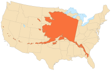
Alaska
Indigenous people have lived in Alaska for thousands of years, and it is widely believed that the region served as the entry point for the initial settlement of North America by way of the Bering land bridge.
Ben Potter, the University of Alaska Fairbanks archaeologist who unearthed the remains at the Upward Sun River site in 2013, named this new group Ancient Beringian.
[15] The Tlingit people developed a society with a matrilineal kinship system of property inheritance and descent in what is today Southeast Alaska, along with parts of British Columbia and the Yukon.
This hypothesis is based on the testimony of Chukchi geographer Nikolai Daurkin, who had visited Alaska in 1764–1765 and who had reported on a village on the Kheuveren River, populated by "bearded men" who "pray to the icons".
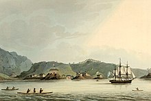
[18] The first European vessel to reach Alaska is generally held to be the St. Gabriel under the authority of the surveyor M. S. Gvozdev and assistant navigator I. Fyodorov on August 21, 1732, during an expedition of Siberian Cossack A. F. Shestakov and Russian explorer Dmitry Pavlutsky (1729–1735).
[21] Russia's contemporary ruler Tsar Alexander II, the Emperor of the Russian Empire, King of Poland and Grand Duke of Finland, also planned the sale;[22] the purchase was made on March 30, 1867.
[27] On March 27, 1964, the massive Good Friday earthquake killed 133 people and destroyed several villages and portions of large coastal communities, mainly by the resultant tsunamis and landslides.
Anchorage sustained great destruction or damage to many inadequately earthquake-engineered houses, buildings, and infrastructure (paved streets, sidewalks, water and sewer mains, electrical systems, and other human-made equipment), particularly in the several landslide zones along Knik Arm.
Southeast of Anchorage, areas around the head of Turnagain Arm near Girdwood and Portage dropped as much as 8 feet (2.4 m), requiring reconstruction and fill to raise the Seward Highway above the new high tide mark.
Post-quake tsunamis severely affected Whittier, Seward, Kodiak, and other Alaskan communities, as well as people and property in British Columbia, Washington, Oregon, and California.
[37] Chance provided breaking news of the catastrophic events that continued to develop following the magnitude 9.2 earthquake, and she served as the voice of the public safety office, coordinating response efforts, connecting available resources to needs around the community, disseminating information about shelters and prepared food rations, passing messages of well-being between loved ones, and helping to reunite families.
[38] In the longer term, the U.S. Army Corps of Engineers led the effort to rebuild roads, clear debris, and establish new townsites for communities that had been completely destroyed, at a cost of $110 million.
[40] In 1989, the Exxon Valdez hit a reef in the Prince William Sound, spilling more than 11 million gallons (42 megalitres) of crude oil over 1,100 miles (1,800 km) of coastline.
Today, the battle between philosophies of development and conservation is seen in the contentious debate over oil drilling in the Arctic National Wildlife Refuge and the proposed Pebble Mine.
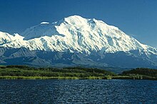
Geologists have identified Alaska as part of Wrangellia, a large region consisting of multiple states and Canadian provinces in the Pacific Northwest, which is actively undergoing continent building.
[51] The Alaska Marine Highway provides a vital surface transportation link throughout the area and country, as only three communities (Haines, Hyder and Skagway) enjoy direct connections to the contiguous North American road system.
Some of these islands fall in the Eastern Hemisphere, but the International Date Line was drawn west of 180° to keep the whole state, and thus the entire North American continent, within the same legal day.
The survey's inventory of cultural resources includes objects, structures, buildings, sites, districts, and travel ways, with a general provision that they are more than fifty years old.
An area stretching from the northern side of the Seward Peninsula to the Kobuk River valley (i.e., the region around Kotzebue Sound) is technically a desert, with portions receiving less than 10 in (25 cm) of precipitation annually.
[110] In 2018, The Gospel Coalition published an article using Pew data and determined non-churchgoing Christians nationwide did not attend religious services often through the following: practicing the faith in other ways, not finding a house of worship they liked, disliking sermons and feeling unwelcomed, and logistics.
Its industrial outputs are crude petroleum, natural gas, coal, gold, precious metals, zinc and other mining, seafood processing, timber and wood products.
[137] Rural Alaska suffers from extremely high prices for food and consumer goods compared to the rest of the country, due to the relatively limited transportation infrastructure.
An example of a traditional native food is Akutaq, the Eskimo ice cream, which can consist of reindeer fat, seal oil, dried fish meat and local berries.
[178] Making regular flights to most villages and towns within the state commercially viable is difficult, so they are heavily subsidized by the federal government through the Essential Air Service program.
The bulk of remaining commercial flight offerings come from small regional commuter airlines such as Ravn Alaska, PenAir, and Frontier Flying Service.
The world's busiest seaplane base is Lake Hood, located next to Ted Stevens Anchorage International Airport, where flights bound for remote villages without an airstrip carry passengers, cargo, and many items from stores and warehouse clubs.
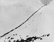
The "Serum Run" is another sled dog race that more accurately follows the route of the famous 1925 relay, leaving from the community of Nenana (southwest of Fairbanks) to Nome.
[181] In areas not served by road or rail, primary transportation in summer is by all-terrain vehicle and in winter by snowmobile or "snow machine", as it is commonly referred to in Alaska.
[184] In January 2011, it was reported that a $1 billion project to connect Asia and rural Alaska was being planned, aided in part by $350 million in stimulus from the federal government.
A part of the revenue collected from certain state taxes and license fees (such as petroleum, aviation motor fuel, telephone cooperative) is shared with municipalities in Alaska.