Climate of Australia
The climate is variable, with frequent droughts lasting several seasons, thought to be caused in part by the El Niño-Southern Oscillation.
[6] Because of its higher general elevation of over 650 m (2,130 ft), southern latitude and entirely landlocked location, winters are exclusively cool to cold in the Australian Capital Territory.
On a hot summer day, a southerly buster may at times moderate the extreme heat experienced in the coastal New South Wales region, from Port Macquarie southwards to Nowra.
The weather in the northeast region of the state, or the North Coast, bordering Queensland, is moderately hot, humid and rainy in the summer, and mild in winter with more sunshine; and little seasonal temperature difference.
The Northern Tablelands have relatively milder summers and colder winters, due to their high elevation and inland location on the Great Dividing Range.
The southeast coastal plain, which lies on the leeward side of the Great Dividing Range, experiences foehn winds, particularly between winter and spring, which can elevate fire danger.
The majority of rainfall occurs between December and March (the Southern Hemisphere summer), when thunderstorms are common and afternoon relative humidity averages over 70% during the wettest months.
The rest of the territory lies in the desert centre of the country; it includes Alice Springs and Uluru, and is arid or semi-arid with little rain usually falling during the hottest months from October to March.
Low rainfall and hot summers are typical for the inland west, a monsoonal 'wet' season in the far north, and warm subtropical conditions along the coastal strip.
The climate of the coastal strip is influenced by warm ocean waters, keeping the region free from extremes of temperature and providing moisture for rainfall.
Most of the rain in the southern districts of the State fall during the winter months when the sub-tropical high-pressure belt is displaced to the north over the Australian continent.
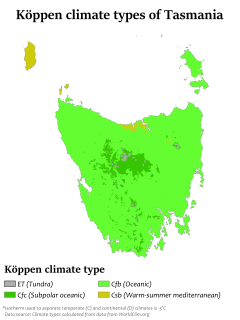
Other inland areas are much cooler; Liawenee, located on the Central Plateau, is one of the coldest places in Australia with February temperatures ranging between 4 and 17 °C (39 and 63 °F).
Victoria's main land feature, the Great Dividing Range, produces a cooler, mountain climate in the centre and east of the state.
Due to the offshore Leeuwin Current, the area numbers in the top six regions for marine biodiversity, containing the most southerly coral reefs in the world.
The Kimberley has an extremely hot monsoonal climate with average annual rainfall ranging from 500 to 1,500 mm (20 to 59 in), but there is a very long dry season of 7 months from April to November.
A 2005 study by Australian and American researchers[74] investigated the desertification of the interior, and suggested that one explanation was related to human settlers who arrived about 50,000 years ago.
The absence of any significant mountain range or area of substantial height above sea level, results in very little rainfall caused by orographic uplift.
In July, a more common latitudinal distribution of average maximums is apparent, ranging from 30 °C near the north coast to below 3 °C in the mountainous areas of the south-east.
The highest average January minimum temperatures (near 27 °C) are found near the north-west coast, while in winter they exceed 20 °C at some coastal locations in northern Australia and on the Torres Strait and Tiwi Islands.
[132] Many of the worst bushfires in eastern Australia, such as the 1983 Ash Wednesday fires, accompany El Niño–Southern Oscillation events which tend to cause a warm, dry and windy climate.
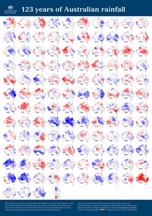
Specifically drought in Australia is defined in relation to a rainfall deficiency of pastoral leases and is determined by decile analysis applied to a certain area.
Through La Niña years the eastern seaboard of Australia (east of the Great Dividing Range) records above-average rainfall, usually creating damaging floods.
The 2010–2011 La Niña system broke many rainfall records in Australia, particularly in the states of Queensland and New South Wales, with extensive flooding and major damage to infrastructure and crops.
[142] Tropical cyclones are known to bring destructive winds, heavy rain with flooding creating storm surges along the coast, causing inundation to low-lying areas.
[144] Cyclone Mahina in 1899 brought a storm surge to Far North Queensland reaching 13 metres (43 ft) high, causing 400 deaths and making it the worst natural disaster to befall Australia.
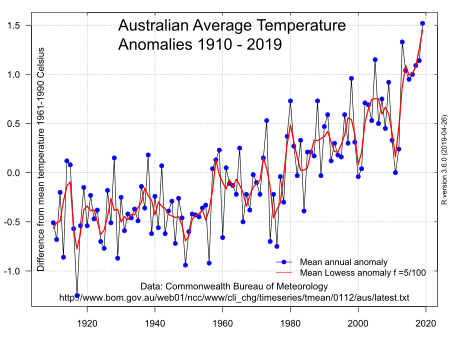
Australia is becoming hotter and more prone to extreme heat, bushfires, droughts, floods, and longer fire seasons because of climate change.
Average precipitation in the southwest and southeast Australia is projected to decline during this time, while regions such as the northwest may experience increases in rainfall.
[155] Furthermore, Australia's population is highly concentrated in coastal areas at risk from rising sea levels, and existing pressures on water supply will be exacerbated.
The exposure of Indigenous Australians to climate change impacts is exacerbated by existing socio-economic disadvantages which are linked to colonial and post-colonial marginalisation.
[156] Aboriginal and Torres Strait Islander communities located in the coastal north are the most disadvantaged due to social and economic issues and their reliance on traditional land for food, culture, and health.