Climate of New Zealand
The main contributing factors are the Pacific Ocean and latitude, although the mountain ranges can cause significant climate variations in locations barely tens of kilometres from each other.
Conditions vary from extremely wet on the West Coast of the South Island to almost semi-arid in Central Otago and subtropical in Northland.
Northern and eastern parts of the country, including Auckland, Christchurch and Wellington see a slight winter maximum consistent with a Mediterranean climate.
The Southern Alps, the North Island Volcanic Plateau and surrounding ranges can produce large variation in rainfalls in places barely tens of kilometres apart.
The humid westerly wind is forced up over the mountains, at cooler elevation water condenses and falls as snow or rain.
This orographic rain explains the huge difference in conditions between the wet west and dry east of the South Island.
[4] The drier föhn wind descending the eastern slopes of the Southern Alps gives rise to a distinctive local weather phenomenon, the Nor'west arch, visible in much of Canterbury and parts of Otago.
Tornadoes in New Zealand most often form from squall lines ahead of cold fronts, which have the potential to spawn mesocyclones capable of tornadogenesis.
Central Otago and inland Canterbury's Mackenzie Basin have the closest New Zealand has to continental climates, being generally drier (due in part to föhn winds) and less directly modified by the ocean.
The exception to this is inland areas and to the east of the ranges with daily variations that can be over 25 °C and differences of up to 14 °C between the average summer and winter high temperatures.
They are higher in northern, eastern and interior part of the country; Hastings is the warmest city on average with 25.5 °C followed by Gisborne with 24.9 °C and Napier with 24.5 °C.
Due to these winds, the cooler South Island cities such as Dunedin, Christchurch and Invercargill have higher all-time record temperatures than places further north such as Wellington, Auckland and Whangārei.
Winter temperatures are considerably milder in New Zealand compared to other areas of similar latitude, with the exception of the Central Otago and Mackenzie Basin regions mentioned above.
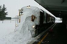
[7] July 1863 The blizzard and flood of 1863 was a series of consecutive natural disasters in Central Otago in New Zealand's South Island.
[9] 10 April 1968: Cyclone Giselle caused peak gusts of 145 knots (270 km/h) near Wellington, after colliding with an Antarctic storm moving north.
Landslides destroyed houses and a boy was killed by a collapsing wall when a slip struck a hall in Crofton Downs.
[10] 26 June 1998: A severe thunderstorm affected Karori and Kelburn, with rain breaking all previous records and falling at a rate with a return period of well over 200 years.
Similar storms, some with hail and surface flooding also happened in Whanganui, Manawatu, the central and eastern North Island, Buller and Nelson.
[10] 14–16 February 2004: The Valentine's Day storms left hundreds of people homeless, and silt and floodwaters inundated considerable areas of farmland.
12-16 February 2023: The extratropical remnants of Cyclone Gabrielle passed over the North Island bringing heavy rain and damaging winds causing serious flooding in a number of regions.
The key facts to emerge are that New Zealand did experience a noticeable cooler climate, but at a slightly later date than in the Northern Hemisphere.
Since 2000 various scientific investigations looked at the behaviour of glaciers in relation to climate and found they were excellent indicators of temperatures, especially in summer.
The dominant temperature influence here was the relative warmth of the sea to the south of New Zealand during the Medieval Warm Period (MWP).
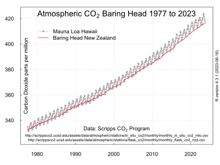
[26][27] More than half (53%) of New Zealand's gross greenhouse gas emissions are from agriculture, mainly methane from sheep and cow belches.