Otago
It has an area of approximately 32,000 square kilometres (12,000 sq mi),[5] making it the country's second largest local government region.
"Otago" is also the old name of the European settlement on the harbour, established by the Weller Brothers in 1831, which lies close to Otakou.
The upper harbour later became the focus of the Otago Association, an offshoot of the Free Church of Scotland, notable for its adoption of the principle that ordinary people, not the landowner, should choose the ministers.
[8] The Otago settlement, an outgrowth of the Free Church of Scotland, was founded in March 1848 with the arrival of the first two immigrant ships from Greenock on the Firth of Clyde — the John Wickliffe and the Philip Laing.
Otago citizens subsequently elected him to the office of provincial Superintendent after the New Zealand provinces were created in 1853.
Initial settlement was concentrated on the port and city, then expanded, notably to the south-west, where the fertile Taieri Plains offered good farmland.
[11] Veterans of goldfields in California and Australia, plus many other fortune-seekers from Europe, North America and China, poured into the then Province of Otago, eroding its Scottish Presbyterian character.
Further gold discoveries at Clyde and on the Arrow River around Arrowtown led to a boom, and Otago became for a period the cultural and economic centre of New Zealand.
The provincial governments were abolished in 1876 when the Abolition of the Provinces Act came into force on 1 November 1876,[14] and were replaced by other forms of local authority, including counties.
In this part of Otago glacial activity – both recent and very old – dominates the landscape, with large U-shaped valleys and rivers which have high sediment loads.
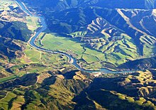
Along its course it forms two notable geographic features – the broad high valley of the Strath-Taieri in its upper reaches, and the fertile Taieri Plains as it approaches the ocean.
In contrast to Canterbury, where the Northwest winds blow across the plains without interruption, in Otago the block mountains impede and dilute the effects of the Nor'wester.
The main Central Otago centres, such as Alexandra and Cromwell, are found in the intermontane basins between the block mountains.
The schist bedrock influence extends to the eastern part of Otago, where remnant volcanics mark its edge.
Comparatively similar terrain exists in the high plateau land of the Maniototo Plain, which lies to the east of Central Otago, close to the upper reaches of the Taieri River.
This itself forms part of a larger system known as the Southland Syncline, which links to similar formations in Nelson (offset by the Alpine Fault) and even in New Caledonia, 3,500 km (2,200 mi) away.
[17] The Catlins ranges are strike ridges composed of Triassic and Jurassic sandstones, mudstones and other related sedimentary rocks, often with a high incidence of feldspar.
[18] Coastal regions of Otago are subject to the alternating warm and dry/cool and wet weather patterns common to the interannual Southern oscillation.
Drier conditions are often the result of the northwesterly föhn wind, which dries as it crosses the Southern Alps.
A common variant in this pattern is the centring of a stationary low-pressure zone to the southeast of the country, resulting in long-lasting cool, wet conditions.
Unlike other southern centres, Dunedin's population has not declined since the 1970s, largely due to the presence of the University of Otago – and especially its medical school – which attracts students from all over New Zealand and overseas.
[21] Other significant urban centres in Otago with populations over 1,000 include: Queenstown, Oamaru, Wānaka, Port Chalmers, Cromwell, Alexandra, Balclutha, Milton and Mosgiel.
Other significant ethnic minorities include Asians, Pacific Islanders, Africans, Latin Americans and Middle Easterners.
[27] Otago's early waves of settlement, especially during and immediately after the gold rush of the 1860s, included a substantial minority of southern (Guangdong) Chinese settlers, and a smaller but also prominent number of people from Lebanon.
The early and middle years of the twentieth century saw smaller influxes of immigrants from several mainland European countries, most notably the Netherlands.
Under the Māori electorates system, Otago is also part of the large Te Tai Tonga electorate, which covers the entire South Island and surrounding islands, and is currently held by Te Pāti Māori Party MP Tākuta Ferris.
Vineyard planting and production remained modest until the middle of the 1990s when the New Zealand wine industry began to expand rapidly.