Cloud physics
Advances in weather radar and satellite technology have also allowed the precise study of clouds on a large scale.
If the condensation process occurs below the freezing level in the troposphere, the nuclei help transform the vapor into very small water droplets.
[10] Frontal and cyclonic lift occur in their purest manifestations when stable air, which has been subjected to little or no surface heating, is forced aloft at weather fronts and around centers of low pressure.
[13] Another agent is the buoyant convective upward motion caused by significant daytime solar heating at surface level, or by relatively high absolute humidity.
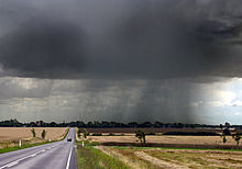
If air near the surface becomes extremely warm and unstable, its upward motion can become quite explosive, resulting in towering cumulonimbiform clouds that can cause severe weather.
As tiny water particles that make up the cloud group together to form droplets of rain, they are pulled down to earth by the force of gravity.
However, very warm unstable air can also be present around fronts and low-pressure centers, often producing cumuliform and cumulonimbiform clouds in heavier and more active concentrations because of the combined frontal and convective lifting agents.
As with non-frontal convective lift, increasing instability promotes upward vertical cloud growth and raises the potential for severe weather.
On comparatively rare occasions, convective lift can be powerful enough to penetrate the tropopause and push the cloud top into the stratosphere.
Increased vapor content can result from wind convergence over water or moist ground into areas of upward motion.
[citation needed] Supersaturation of more than 1–2% relative to water is rarely seen in the atmosphere, since cloud condensation nuclei are usually present.
[citation needed] One theory explaining how the behavior of individual droplets in a cloud leads to the formation of precipitation is the collision-coalescence process.
The collision-coalescence process does not make up a significant part of cloud formation, as water droplets have a relatively high surface tension.
The Bergeron process relies on super cooled liquid water (SLW) interacting with ice nuclei to form larger particles.
[citation needed] Clouds in the troposphere, the atmospheric layer closest to Earth, are classified according to the height at which they are found, and their shape or appearance.
[32] Cirriform clouds are high, thin and wispy, and are seen most extensively along the leading edges of organized weather disturbances.
Stratiform clouds are non-convective and appear as extensive sheet-like layers, ranging from thin to very thick with considerable vertical development.
Stratocumuliform clouds of limited convection show a mix of cumuliform and stratiform characteristics which appear in the form of rolls or ripples.
Stratiform and stratocumuliform clouds in the high level of the troposphere have the prefix cirro- added to their names yielding the genera cirrostratus and cirrocumulus.
Similar clouds found in the middle level (altitude range 2 to 7 kilometers) carry the prefix alto- resulting in the genus names altostratus and altocumulus.
Small cumulus clouds with little vertical development (species humilis) are also commonly classified as low level.
Of the vertically developed clouds, the cumulonimbus type is the tallest and can virtually span the entire troposphere from a few hundred metres above the ground up to the tropopause.
[35] The method of detection is based on the fact that the clouds tend to appear brighter and colder than the land surface.
[35] The Global Energy and Water Cycle Experiment uses the following quantities in order to compare data quality from different satellites in order to establish a reliable quantification of the properties of the clouds:[35] Another vital property is the icing characteristic of various cloud genus types at various altitudes, which can have great impact on the safety of flying.
It has been speculated that as long as the air remains saturated, the natural force of cohesion that hold the molecules of a substance together may act to keep the cloud from breaking up.
However, this speculation has a logical flaw in that the water droplets in the cloud are not in contact with each other and therefore not satisfying the condition required for the intermolecular forces of cohesion to act.
Dissolution of the cloud can occur when the process of adiabatic cooling ceases and upward lift of the air is replaced by subsidence.
This leads to at least some degree of adiabatic warming of the air which can result in the cloud droplets or crystals turning back into invisible water vapor.
[37] Stronger forces such as wind shear and downdrafts can impact a cloud, but these are largely confined to the troposphere where nearly all the Earth's weather takes place.
[39] There are two main model schemes that can represent cloud physics, the most common is bulk microphysics models that uses mean values to describe the cloud properties (e.g. rain water content, ice content), the properties can represent only the first order (concentration) or also the second order (mass).