Cold-core low
[3] The movement of cold-core cyclones can be erratic since they are separated from the main belt of the Westerlies, which would otherwise steer them progressively to the east.
[4] Most cloud cover and precipitation in association with cold lows occurs during the daylight hours as sunlight warms the Earth's surface, destabilizing the atmosphere and causing upward vertical motion.
In the case of the north Indian Ocean, the formation of this type of vortex leads to the onset of monsoon rains during the wet season.
Those offshore the East Coast of the United States, which normally form in the months between October and April, are termed nor'easters.
[9] Not initially associated with weather fronts, they form in tandem with blocking anticyclones at higher latitudes, which leads to a slow poleward movement up the SST gradient.
These systems can develop strong wind, heavy rains, waves over 10 metres (33 ft) in height, and eye features on weather satellite imagery.
[10] Upper-level lows are usually the cause of heavy rainfall and storms in southeastern Australia, particularly during La Niña years.
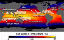
[17] Normally, an ocean temperature of 26.5 °C (79.7 °F) spanning through a depth of at least 50 metres (160 ft) is one of the six requirements needed to maintain the special mesocyclone that is the tropical cyclone.