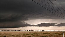
Wall cloud
[2] It is typically beneath the rain-free base (RFB)[3] portion of a thunderstorm, and indicates the area of the strongest updraft within a storm.
In the Northern Hemisphere wall clouds typically form at the south or southwest end of a supercell.
When present in a supercell thunderstorm these shelf clouds on the leading edge of a storm are associated with the forward flank downdraft (FFD).
[8][9] A wall cloud will usually be at the rear of the storm, though small, rotating wall clouds (a feature of a mesovortex) can occur within the leading edge (typically of a quasi-linear convective system (QLCS) or squall line) on rare occasion.
Often, the degree of ascent and rotation increase markedly shortly before tornadogenesis, and sometimes the wall cloud will descend and "bulk" or "tighten".
This should be sensible at the surface if one is in the inflow region; in the Northern Hemisphere, this is typically to the south and southeast of the wall cloud.
Large tornadoes tend to come from larger, lower-wall clouds closer to the back of the rain curtain (providing less visual warning time to those in the path of an organized storm).
Absent the co-position of a low-level boundary with an updraft, tornadoes very rarely occur without a sufficiently buoyant rear flank downdraft (RFD), which usually manifests itself visually as a drying out of clouds, called a clear slot or notch.
Usually, but not always, the dry slot occlusion is visible (assuming one's line of sight is not blocked by precipitation) throughout the tornado life cycle.
If conditions are favorable, then, often even before the original tornado lifts, another wall cloud and occasionally a new tornado may form downwind of the old wall cloud, typically to the east or the southeast in the Northern Hemisphere (east or northeast in the Southern Hemisphere).


