Mesoscale convective system
A mesoscale convective system's overall cloud and precipitation pattern may be round or linear in shape, and include weather systems such as tropical cyclones, squall lines, lake-effect snow events, polar lows, and mesoscale convective complexes (MCCs), and generally forms near weather fronts.
One exception is that of lake-effect snow bands, which form due to cold air moving across relatively warm bodies of water, and occurs from fall through spring.
Once the parent MCS dies, later thunderstorm development can occur in connection with its remnant mesoscale convective vortex (MCV).
MCS is a more generalized term which includes systems that do not satisfy the stricter size, shape, or duration criteria of an MCC.
They tend to form near weather fronts and move into areas of 1000-500 mb thickness diffluence, which are areas where the low to mid level temperature gradient broadens, which generally steers the thunderstorm clusters into the warm sector of extratropical cyclones, or equatorward of warm fronts.
Organized thunderstorms and thunderstorm clusters/lines can have longer life cycles as they form in environments of sufficient moisture, significant vertical wind shear (normally greater than 25 knots (13 m/s) in the lowest 6 kilometres (3.7 mi) of the troposphere)[5]), which aids the development of stronger updrafts as well as various forms of severe weather.
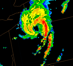
They are long-lived, nocturnal in formation as they tend to form overnight, and commonly contain heavy rainfall, wind, hail, lightning and possibly tornadoes.
[13] The squall line contains heavy precipitation, hail, frequent lightning, strong straight-line winds, and possibly tornadoes and waterspouts.
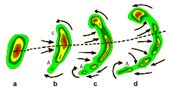
[16] Some bow echoes that develop within the summer season are known as derechos, and they move quite fast through large sections of territory.
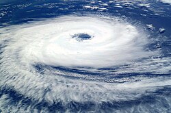
[19] A tropical cyclone is a fairly symmetric storm system characterized by a low pressure center and numerous thunderstorms that produce strong winds and flooding rain.
[21] Tropical cyclones can produce extremely powerful winds and torrential rain, as well as high waves and damaging storm surge.
[25] They also carry heat and energy away from the tropics and transport it toward temperate latitudes, which makes them an important part of the global atmospheric circulation mechanism.
This uplifting can produce narrow, but very intense bands of precipitation, which is deposited at a rate of many inches of snow per hour and often brings copious snowfall totals.
[31] Lake-effect occurring when the air at 850 millibars is 25 °C (45 °F) colder than the water temperature can produce thundersnow, snow showers accompanied by lightning and thunder (due to the larger amount of energy available from the increased instability).
Polar lows can be difficult to detect using conventional weather reports and are a hazard to high-latitude operations, such as shipping and gas and oil platforms.
On average, a European MCS moves east-northeast, forming near 3 p.m. local solar time, lasts 5.5 hours, dissipating near 9 p.m. LST.
[37] Mesoscale convective systems, which can evolve into tropical cyclones, form along areas such as tropical waves or easterly waves which progress westward along monsoon troughs and the Intertropical Convergence Zone in regions of ample low level moisture, convergent surface winds, and divergent winds aloft.
[39] In the cases of Lake-effect snow and polar lows, the convective systems form over warm water bodies when cold air sweeps over their surface and leads to an increase in moisture and significant vertical motion.