Volcán de Colima
[4] Nevado de Colima, also known as Tzapotépetl, lies 5 kilometres (3.1 mi) north of its more active neighbor and is the taller of the two at 4,271 meters (14,012 feet).
Since 1869–1878, a parasitic set of domes, collectively known as El Volcancito, has formed on the northeast flank of the main cone of the volcano.
[6] In the late Pleistocene era, a huge landslide occurred at the mountain, with approximately 25 km3 (6.0 cu mi) of debris traveling some 120 km, reaching the Pacific Ocean.
[4] In light of its history of large eruptions and situation in a densely populated area, it was designated a Decade Volcano, singling it out for study.
In recent years, there have been frequent temporary evacuations of nearby villagers due to threatening volcanic activity.
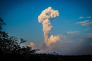
Eruptions have occurred in 1991, 1998–1999 and from 2001 to the present day, with activity being characterized by extrusion of viscous lava forming a lava dome, and occasional larger explosions, forming pyroclastic flows and dusting the areas surrounding the volcano with ash and tephra.
Another eruption occurred on September 25, 2016, sending a plume of ash and smoke 10,000 feet (3,000 m) into the sky.