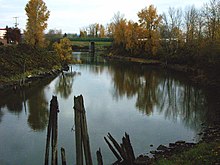
Columbia Slough
In the early 19th century fur trappers and explorers including Lewis and Clark visited the area before large migrations of settlers began arriving from the east.
The newcomers farmed, cut timber, built houses, and by the early 20th century established cities, shipping ports, roads, rail lines and industries near the slough.
State and local governments, often assisted by community volunteers, undertook projects related to public health, natural resources, and recreation in a region with many homes, industries, businesses, and roads.
[7] The Columbia Slough is classified as a "stream" in the Geographic Names Information System (GNIS) of the United States Geological Survey (USGS).
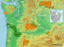
[13] Parts of Portland, Fairview, Gresham, Maywood Park, Wood Village, and unincorporated Multnomah County lie within the drainage basin (watershed).
[3] The watershed includes residential neighborhoods, agriculture, the airport, open spaces, 54 schools, interstate highways, railways, commercial businesses, and heavy and light industry.
[21] The Port of Portland, a regional agency run by commissioners appointed by the Oregon governor, owns and manages about 11 percent of the land in the slough watershed.
[21] In 2015, Portland's Bureau of Environmental Services (BES) began issuing annual "report cards" for watersheds or fractions thereof that lie within the city.
Hydrology grades depend on the amount of pavement and other impervious surfaces in the watershed and to what degree its streams flow freely, not dammed or diverted.
[29] About 10 million years ago, eruptions of Cascade Range volcanoes to the east sent flows of mud, ash, and eroded volcanic debris into the Columbia, which was powerful enough to carry the material downstream.
About 3 million years ago, many small volcanoes and cinder cones erupted through the thin, stretched crust of the basin and in the Cascade foothills to the southeast.
The floodwaters ripped the face off Rocky Butte in Portland and deposited a 5-mile (8 km) gravel bar, Alameda Ridge, that runs parallel to and slightly south of the Columbia Slough.
Urban development, which replaced vegetation and water-absorbing soils with airport runways, house roofs, highways, warehouses, parking lots, and other hard surfaces, interrupted this cycle.
[36] A fourth district, the Sandy Drainage Improvement Company (SDIC), manages water flow at the upper end of the slough's basin in Fairview and Troutdale.
[47] By the 1830s, smallpox, malaria, measles and other diseases carried by non-indigenous explorers and traders had reduced the native population by up to 90 percent throughout the lower Columbia basin.
[53] These and other early 20th century businesses, including stockyards, a dairy farm, a shingle company, and a lumber mill, flushed waste products into the slough.
They dug ditches, deepened existing water channels, and built levees to keep the rivers and the slough from flooding agricultural, industrial, and commercial property.
Activists and civic leaders, concerned about pollution on the Willamette River, led cleanup campaigns, but voters declined to pay for sewage treatment.
[44] After the start of the war with Japan, President Franklin D. Roosevelt signed an order for internment of all the people of Japanese ancestry who lived on the West Coast.
[55] In 1942, Kaiser Shipbuilding Company began making ships for the war at three huge installations near the lower slough, one in St. Johns, one on Swan Island in Portland's Overlook neighborhood, and one in Vancouver, Washington.
[56] To house shipyard workers and their families, Henry J. Kaiser bought 650 acres (260 ha) of former marsh, pasture, and farmland in the lower slough watershed surrounded on all sides by dikes between 15 and 25 feet (5 and 8 m) high.
[44] In the 1970s, the Oregon Legislature passed a law against filling Smith or Bybee lakes below a contour line 11 feet (3.4 m) above mean sea level except to enhance fish and wildlife habitat.
[44] In 1986, a business association began promoting commercial development along the upper slough, and the city later used urban renewal funds to support industrial projects near the airport.
In response to a threatened lawsuit, the city began a comprehensive cleanup of the slough in 1994, and a year later it received a $10 million grant from the EPA for the purpose.
[44] Of the streams monitored in the lower Willamette basin by the Oregon Department of Environmental Quality (DEQ) between 1986 and 1995, the Columbia Slough had the worst pollution scores.
The Multnomah County Health Department and other agencies have advised people to avoid or greatly reduce consumption of fish and crayfish from the slough because they contain polychlorinated biphenyls (PCB) and pesticides.
In a report published in 2005, the Portland Bureau of Environmental Services (BES), using data from an early United States General Land Office survey, compared the watershed of 1851 with that of 2003.
[65] In 2002 the city, the MCDD, and the U.S. Army Corps of Engineers began a project to improve habitat by creating 7 miles (11 km) of stream meanders and wetland terraces along the slough.
[81] Whitaker Ponds Nature Park, at about RM 10 (RK 16), is a 25-acre (10 ha) site with a walking trail, canoe launch, garden, and wildflower meadow.
Originally proposed by the Olmsted Brothers, architects involved in the planning for Portland's Lewis and Clark Centennial Exposition of 1905, it has expanded to a projected 140 miles (230 km), encircling the city and connecting parks along the Columbia, Sandy, and Willamette rivers and Johnson Creek.