Tryon Creek
Part of the drainage basin of the Columbia River, its watershed covers about 6.5 square miles (16.8 km2) in Multnomah and Clackamas counties.
The stream flows southeast from the Tualatin Mountains (West Hills) through the Multnomah Village neighborhood of Portland and the Tryon Creek State Natural Area to the Willamette in the city of Lake Oswego.
The bedrock under the watershed includes part of the last exotic terrane, a chain of seamounts, acquired by the North American Plate as it moved west during the Eocene.
Known as the Waverly Hills Formation, it lies buried under ash and lava from later volcanic eruptions, sediments from flooding and erosion, and layers of wind-blown silt.
Tryon Creek begins slightly north of Interstate 5 (I-5) and Oregon Route 99W near Multnomah Village and flows southeast for 4.85 miles (7.81 km)[7] through Portland residential neighborhoods as well as Marshall Park and the Tryon Creek State Natural Area to its confluence with the Willamette River in the city of Lake Oswego.
Almost immediately, the creek enters a culvert, about 150 feet (46 m) long, that passes under Southwest Boones Ferry Road.
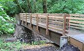
Then Tryon Creek passes under the High Bridge, the uppermost of five footbridges that span the main stem within the park.
Below this, Tryon Creek forms the boundary between the city of Lake Oswego and Briarwood, an unincorporated Clackamas County community, which is to the left.
[12] Part of the last major exotic terrane acquired by the North American Plate during the Eocene lies under the Tryon Creek watershed.
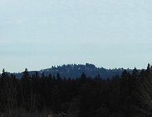
The terrane consisted of a chain of seamounts that by 34 million years ago was being uplifted to become the Oregon Coast Range and the Tualatin Mountains (West Hills).
[15] Starting about 3 million years ago and continuing at least through the late Pleistocene, extensional faulting of the Earth's crust led to eruption of small volcanoes in the Boring volcanic field.
This field extended roughly from Portland and Tualatin on the west to Battle Ground, Washington, on the north to Sandy and Boring on the east.
The Mount Sylvania eruptions included ash plumes and lava flows that covered some of the Waverly Heights Formation and Columbia River basalts.
[19] These surfaces and the relatively impermeable silt and clay soils that underlie the area contribute to rapid runoff and low baseflows in the creek and its tributaries.
[8] The seven named tributaries from mouth to source are Nettle, Palatine Hill, Red Fox, Park, Fourth Avenue, Arnold, and Falling creeks.
[22] The State of Oregon listed Tryon Creek as "water-quality limited" in 1998 because water temperatures on the lower 5 miles (8 km) of the main stem as well as on Nettle, Arnold, and Falling creeks exceeded the upper limit for protecting salmonid fish rearing and migratory fish passage during the summer.
Two are near I-5 and Barbur Boulevard in the upper watershed, and the third is at Southwest Boones Ferry Road, about 2.7 miles (4.3 km) from the mouth.
Hydrology grades depend on the amount of pavement and other impervious surfaces in the watershed and the degree to which its streams flow freely, not dammed or diverted.
Water-quality grades are based on measurements of dissolved oxygen, E-coli bacteria, temperature, suspended solids, and substances such as mercury and phosphorus.
Habitat ranking depends on the condition of stream banks and floodplains, riparian zones, tree canopies, and other variables.
[31] Another group of Chinookans, the Multnomahs, lived on Sauvie Island,[32] about 17 miles (27 km) downriver from the mouth of Tryon Creek.
The land then passed to other relatives, including Socrates Tryon, Jr., who sold the 645 acres (261 ha) in 1874 to the Oregon Iron Company.
In 1900, fire in the upper canyon left charred snags still visible along the natural area's Center and Big Fir trails.
[33] Logging resumed in 1912 in the north part of the canyon, where The Boone's Ferry Wood and Tie Company had a site near what became Alfred Street.
The lumber was used chiefly for railroad ties, cordwood and flagpoles, and left huge cedar stumps that remain in the park.
[33] Over the next few years, the state bought more than 600 acres (240 ha) of land for nearly $3 million, including federal matching funds.
[35] Surveys by the Oregon Department of Fish and Wildlife in 2002 found coho, chinook salmon, steelhead, and coastal cutthroat trout in different parts of the creek at different times of the year.
[35] More than 60 species of birds, including Cooper's hawks, great blue herons, kingfishers, towhees, waxwings, and wrens frequent the area.
Some of the resident mammals are bats, coyotes, moles, rabbits, skunks, and squirrels, while frogs, salamanders, snakes, and turtles also do well in the watershed.
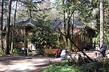
A park building called the Nature Center houses a gift shop, a large classroom, space for educational exhibits, and a play area for small children.