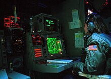
Combat information center
Such polar plots are used routinely in navigation and military action management to display time-stamped range and bearing information to the CIC decision makers.
Harvesting such data sets from the polar plots and computers (Common to sonar, radar and lidar) allows the CIC crew to plot the data correctly on a chart or map at the correct range and bearing, and to calculate the course and speed of the contact accurately, giving the set a vast expansion to include future positions, given unchanged relative courses and relative speeds.
Early versions were used in World War II; according to Rear Admiral Cal Laning, the idea for a command information center was taken “specifically, consciously, and directly” from the spaceship Directrix in the Lensman novels of E. E. Smith, Ph.D.,[3] and influenced by the works of his friend and collaborator Robert Heinlein, a retired American naval officer.
[4] After the numerous losses during the various naval battles off Guadalcanal during the war of attrition in the Solomon Islands campaign and the Battle of Guadalcanal, the United States Navy employed operational analysis, determined many of their losses were due to procedure and disorganization, and implemented the Combat Information Centers, building on what was initially called "radar plot" according to an essay CIC Yesterday and Today by the Naval Historical Center.
The Naval History & Heritage Command essay notes that growing the responsibility of the nascent CIC organization necessarily upset the old order of doing, who was reporting to whom, and most of all, of communications protocols where now CICs within a task group were, when possible, joined in permanent communication links to even the lowliest destroyer escort or fleet auxiliary, adding the eyes and reports of their lookouts to those of similar watch-standers about the fleet as a whole.
In short the CICs continually grew for a time, superseding old organizational structure and supplanting them with a new system filtering and shaping information to a newly empowered command group.