Computer-aided dispatch
CAD provides displays and tools so that the dispatcher has an opportunity to handle calls-for-service as efficiently as possible.
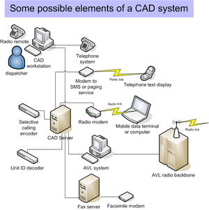
CAD typically consists of a suite of software packages used to initiate public safety calls for service, dispatch, and maintain the status of responding resources in the field.
CAD systems consist of several modules that provide services at multiple levels in a dispatch center and in the field of public safety.
CAD systems also include interfaces that permit the software to provide services to dispatchers, call takers, and field personnel with respect to control and use of analog radio and telephone equipment, as well as logger-recorder functions.
Simply, location, reporting party and incident are the main fields that have to be populated by type-codes.
A typical CAD printout looks something like this based on the example above: Again, granted as it can be seen that the fields are spelled out, the call-taker uses those abbreviations that are already predetermined in order to quickly gather and transmit the information.
To prevent missed messages on critical channels, the select volume may be configured so it cannot be set to an inaudible level.
Unselect channels may be used for special events, other agencies, or purposes that do not involve dispatch and may be inaudible.
The steady, red busy light indicates another dispatch position is transmitting on the channel.
The flashing yellow call light indicates a field unit is talking on the channel.
Since only basic GIS information is included, if AVL was available, it would simply display service vehicle locations on a map.
To make the computing problem easier, the CAD system may use centroids to evaluate service vehicle locations.
Staff based at a fire station that is physically closer by drawing a straight line on the map may be slower to reach a zone.
This can occur because responding units must drive around freeways, lakes, or terrain obstructions in order to reach a zone.
Police and transit, for example, may have different ideas about what boundaries define the ideal zone or how centroids should be weighted.
Can a service vehicle turn left from eastbound Carnegie Street onto northbound Hooligan Boulevard?
At one end of the scoring system there might be an interchange where service vehicles had unrestricted access in making the turn.
In the middle scores, a left turn might be blocked occasionally by heavy traffic, a draw bridge, or street cars.
At the most difficult score, the two streets may cross but the lack of any interchange does not allow service vehicles to get from one to the other.
Routable street centerlines take into account differences between northbound and southbound lanes on a freeway or turnpike.
The analysis of a routable street network takes this into account so long as the event location is accurately reported.
This can lead to concentration of dispatch facilities, particularly where there is population growth or where automation is required to meet defined service objectives.
Evolving standards will allow CAD systems to send messages to one another for calls originating outside local jurisdiction.
Some entities have arrangements that already support data exchange between systems, but standards aim to make these interconnections more common.
[3] This initiative sponsored the IEEE 1512 series of protocols for emergency management[4] which provides sophisticated means to coordinate incidents across operations centers using CAD software.
Additional work is occurring under the National Information Exchange Model[5] to link homeland security with CAD.
Other interoperability technologies can bridge disparities between the data-format, software, and hardware that constitute various computer-aided dispatch systems in various jurisdictions.
One example of such middleware (provided by Utah-based FATPOT Technologies/CII)[8] exists in Orange County, Calif., where the Fire Authority has integrated different emergency service answering points into a seamless dispatching network.
Australia and New Zealand use the ICEMS protocol for messaging between different CAD systems operated by various emergency services organisations.
By using structured call handling and a series of risk calculations, such systems can make objective dispatch recommendations based on information provided by the caller.