Conway, Massachusetts
English colonists first settled Conway in 1762 as the southwestern portion of the Town of Deerfield.
The town was named after General Henry Seymour Conway, a leader in the British House of Commons during the repeal of the Stamp Act.
The town was known for its sheep farming and other agrarian pursuits in its early years, with some industry along the South River.
[4] Conway is in the central part of the county, and is bordered by Shelburne to the north, Deerfield to the east, Whately to the southeast, Williamsburg to the south, Goshen to the southwest, Ashfield to the west, and Buckland to the northwest.
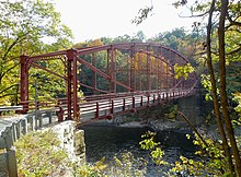
Conway lies south of the Deerfield River, which comprises most of its northern border.
The Bardwell's Ferry Bridge connects Conway to Shelburne across the Deerfield River.
Massachusetts Route 116 passes through the center of town, from Ashfield in the east towards Deerfield, along its way towards Springfield.
The population density was 48.0 inhabitants per square mile (18.5/km2), which ranked sixteenth in the county and 312th in the Commonwealth.
[17] The town is patrolled by the Second (Shelburne Falls) Barracks of Troop "B" of the Massachusetts State Police.
[18] On the national level, Conway is part of Massachusetts's 1st congressional district, and has been represented in the US Congress by House Rep Richard E. Neal (D) since 2012.
Conway is a member of Frontier Regional and Union 38 School Districts, which also includes Deerfield, Whately and Sunderland.
All four towns send seventh through twelfth grade students to Frontier Regional High School in Deerfield.