Shelburne, Massachusetts
It was initially organized as the district of Shelburne in 1768, named in honor of William Petty, 2nd Earl of Shelburne, an Irish-born British politician, who later served as Prime Minister during the American Revolutionary War.
Its character has always been two-sided; the main body of town has farmland among the low hills, while the area around Shelburne Falls has mostly been a milling community.
[3] Shelburne is located in central Franklin County, and is bordered by Colrain to the north, Greenfield to the east, Deerfield to the southeast, Conway to the south, Buckland to the west, and a short, 0.4-mile (0.64 km) stretch of Charlemont to the northwest.
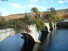
Shelburne lies along the eastern banks of the Deerfield River, which flows along the town's southern and western border.
Several brooks feed into the river through the town, flowing down from several low peaks of the foothills of The Berkshires.
The short, westernmost section of Route 2A connects the highway with the heart of Shelburne Falls, passing into Buckland before finally ending there.
The nearest expressway, Interstate 91, passes through neighboring Greenfield and Deerfield, and can be accessed along Route 2.
The population density was 88.5 inhabitants per square mile (34.2/km2), which ranked tenth in the county and 291st in the Commonwealth.
Shelburne employs the open town meeting form of government, and is led by a board of selectmen.
Buckland-Shelburne Regional Elementary School serves students from pre-kindergarten through sixth grades for the two towns, and students from grades 7–12 attend Mohawk Trail Regional High School in Buckland.
There are several private, religious and charter schools located in the Greenfield area, with the most prominent being Deerfield Academy in Deerfield, Northfield Mount Hermon School in Gill and the Academy at Charlemont in Charlemont.