Crab Creek
Its course exhibits many examples of the erosive powers of extremely large glacial Missoula Floods of the late Pleistocene, which scoured the region.
In addition, Crab Creek and its region have been transformed by the large-scale irrigation of the Bureau of Reclamation's Columbia Basin Project (CBP), which has raised water table levels, significantly extending the length of Crab Creek and created new lakes and streams.
[5] The Columbia Basin Project in central Washington changed the character of Crab Creek substantially.
Potholes Reservoir releases water through canals and has no perennial outlet to Lower Crab Creek.
Hence today the water in Lower Crab Creek comes from ground-water seepage from Potholes Reservoir and irrigation, from the Goose Lake Wasteway, and from tributary inflows downstream of the O'Sullivan Dam.
[8] The water table in this section is variable but generally high due to the low elevation and irrigation runoff.
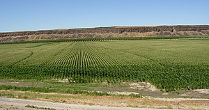
[9] Prior to establishing irrigation, most of the areas along Upper Crab Creek were bunchgrass prairie, which was suited to range cattle and sheep.
Although a handful of ranchers ran herds, shipping their bunchgrass-fed beef to Montana by rail from towns like Sprague, settlement remained extremely sparse.
[10] When the Bureau of Reclamation located district offices in Othello in 1947 and built the Columbia Irrigation Project, the nature of the until then sparsely populated country changed dramatically.
Flowing across the current Grand Coulee-Dry Falls region, the ice-age Columbia then entered the Quincy Basin near Quincy, Washington & joined Crab Creek at Moses Lake, following Crab Creek's course southward past the Frenchman Hills and turning west to run along the north face of the Saddle Mountains, there to rejoin the previous and modern course of the Columbia River just above the main water gap in the Saddle Mountains, Sentinel Gap.
It provides ready access to the Drumheller Channels National Natural Landmark which lies just downstream of the O'Sullivan Dam.