Lake Condon
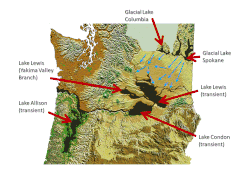
[6] During the last Ice Age (18,000 to 12,000 years ago), and in multiple previous Ice Ages, cataclysmic floods inundated portions of the Pacific Northwest from Glacial Lake Missoula, pluvial Lake Bonneville, and perhaps from subglacial outbursts.
This lake formed from glacial meltwater that was dammed by a lobe of the Canadian ice sheet.
Episodically, perhaps every 40 to 140 years, the waters of this huge lake forced its way past the ice dam, inundating parts of the Pacific Northwest.
Eventually, the ice receded northward far enough that the dam did not reform, and the flooding episodes ceased.
Although the river slowly eroded the land over this period of time, the most drastic changes took place at the end of the last ice age when the Missoula Floods cut the steep, dramatic walls that exist today.