Touchet Formation
[1] The Touchet beds are one element in a chain of evidence which helped identify and define the progression of the Missoula Floods, which occurred around 18,400 to 15,700 calendar years ago.
In 1923, J Harlen Bretz published a paper arguing that the channeled scablands in Eastern Washington were caused by massive flooding in the distant past.
Shaw's team proposed that the rhythmic Touchet beds are the result of multiple pulses, or surges, within a single larger flood.
[14] The Evidence for periods of nondeposition and subaerial exposure between the deposition of individual beds have been further documented and the occurrence of multiple Missoula Floods confirmed by later research.
[3][15] Recent scientific investigations support Waitt's proposed separation of layers into records of sequential flood events.
Some of the suspended materials settled out, creating thick Touchet Formation layers, or rhythmites, which are found throughout these valleys.
He postulated that these floods could occur only when glacial Lake Missoula existed,[10] which estimates place at 18,400 to 15,700 calendar years ago[5] More recent studies have used radiocarbon dating to establish the approximate ages of deposition for the various layers.
The number of layers observed decreases as one progresses up-valley, indicating that the floodwater lakes varied in depth and distance upstream from the various flood dams.
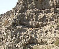
Clastic dike intrusions are observed in some locations penetrating the layers vertically; the dikes are infilled with uniform-size fine-grained materials and are indications that the period between floods was long enough that the deposits dried, forming vertical cracks and allowing wind-blown eroded materials to infill the cracks.
This area was filled to varying depths by the successive Missoula Floods, and sediments settled out to form the Touchet beds over much of the basin, creating what is today a fertile farmland region.
[7][22] The Tucannon River and its tributary, the Pataha Creek also have valleys partially filled with alluvial deposits from the Missoula and Bonneville floods.
One notable location is the White Bluffs, which are made up of more thickly bedded deposits from the eddy that formed in the floodwaters behind the Saddle Mountains.
[8] As one example, silt-sand rhythmites associated with the Missoula Floods are present along Willow Creek, a valley tributary to the Columbia River.
Excellent exposures of the unit (which contains abundant clastic dikes) can be found in roadcuts along Hwy 74 (Heppner Highway) near the ranching community of Cecil, Oregon.