Lake Lewis
Water also backed up further downstream on the Columbia River between Washington and Oregon, delaying the drainage of Lake Lewis.
The Wallula Gap, which has existed for many millions of years, was widened by the prehistoric flow of the Salmon-Snake and Columbia Rivers combined with the glacial waters that poured across the Channeled Scablands during the Missoula Floods.
As a result, the floods filled the Pasco Basin and formed, for a short period, Lake Lewis.
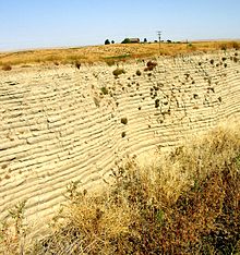
In these relatively calm arms of the lake, the slackwaters were thick with suspended materials eroded from the scablands above.
Some of the suspended materials settled out, creating thick Touchet Formation layers which are found throughout these valleys.